Azov-Syvash National Nature Park
Azov-Syvash National Nature Park (Ukrainian: Азово-Сиваський національний природний парк) is a national park of Ukraine, located on Byriuchyi Island in the northwestern Azov Sea. The park was created to protect the unique coastal environment of the northwestern Azov. It is particularly important as a stop on the flyway for migratory birds, with over a million birds visiting each year. It is located in Henichesk Raion of Kherson Oblast. The park was created on 25 February 1993 and has the area of 52,582.7 hectares (203.023 sq mi).[1][2]
| Azov-Syvash National Nature Park | |
|---|---|
| Ukrainian: Азово-Сиваський національний природний парк | |
IUCN category II (national park) | |
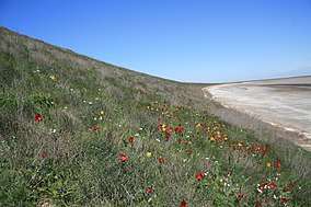 Steppe and coastal beach, Azov-Sivash | |
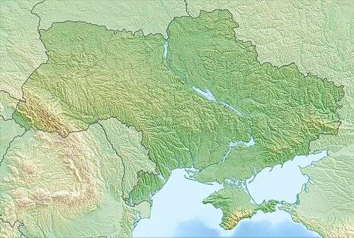 | |
| Location | Henichesk Raion, Kherson Oblast, |
| Nearest city | Henichesk |
| Coordinates | 46°7′33″N 35°4′58″E |
| Area | 525.8 square kilometres (203.0 sq mi) |
| Designation | National Park |
| Established | February 25, 1993 |
| Governing body | State Management of Affairs (Ukraine) |
| Website | http://www.dus.gov.ua/content/azovo-syvaskyy-nacionalnyy-pryrodnyy-park |
Topography
There are two separate areas in the park:[1]
- Azov Site: Byriuchyi Island in the Azov Sea (about 7,700 hectares). The island is in fact connected to land by the narrow Fedotova Spit. The terrain is mostly sand-end-shells estuary plains.
- Syvash Site: The waters and islands of the marine estuary stretching inland along the lagoon-like Syvash Bay (37,785 hectares).

Climate and ecoregion
The park is in the Pontic–Caspian steppe ecoregion.[3]
The official climate designation for the Azov-Syvash area is "Humid continental climate - hot summer sub-type" (Köppen climate classification Dfa), with large seasonal temperature differentials and a hot summer (at least four months averaging over 10 °C (50 °F), at least one of which is over 22 °C (72 °F).[4][5] The average temperature in January is −3 °C (27 °F), and 24 °C (75 °F) in July. Precipitation is among the lowest in Ukraine, with an average of 260 mm/year.
Flora and fauna
The Syvash sector has a dry-steppe environment, with poor soils, and brackish vegetation. The islands in the bay have remained relatively isolated and exhibit more representative southern steppe habitats. Reed beds line portions of the Syvash sector. The Azov site is an important resting spot for migratory birds.[2] The Central Syvash portion of the park is a Ramsar wetland of international importance.[6] The site is also part of an Important Bird and Biodiversity Area (IBA) listed by Birdlife International.[7]
Public use
As a national park, Azov-Syvash is divided into four use-specific zones, providing for a protected area (38,970 hectares in Central Sivash), a regulated recreation zone (618 ha), a local recreation area (93 ha), and an 'economic zone' (12,473 ha).[2]
References
- "Azov-Syvash National Nature Park" (in Ukrainian). State Management of Affairs (Ukraine). Retrieved 12 March 2017.
- "Azov-Sivash Park" (in Ukrainian). Ukraine Incognita. Retrieved August 10, 2019.
- "Map of Ecoregions 2017". Resolve, using WWF data. Retrieved September 14, 2019.
- Kottek, M., J. Grieser, C. Beck, B. Rudolf, and F. Rubel, 2006. "World Map of Koppen-Geiger Climate Classification Updated" (PDF). Gebrüder Borntraeger 2006. Retrieved September 14, 2019.CS1 maint: multiple names: authors list (link)
- "Dataset - Koppen climate classifications". World Bank. Retrieved September 14, 2019.
- "Central Sivash" (PDF). Ramsar Convention. Retrieved August 10, 2019.
- "Syvash Bay". BirdLife International. Retrieved August 10, 2019.
External links
- Borders of Azov-Sivash National Park on OpenStreetMap.org
- Borders of Azov-Sivash National Park on ProtectedPlanet.net
| Wikimedia Commons has media related to Azov-Syvash National Nature Park. |