Aubervilliers – Pantin – Quatre Chemins (Paris Métro)
Aubervilliers - Pantin - Quatre Chemins ([obɛʁvilje pɑ̃tɛ̃ katʁ ʃəmɛ̃]) is a station of the Paris Métro. It is at the crossroads of the Roman road that led from Lutetia to east Flanders (now the N2) and the road between the communes of Aubervilliers and Pantin.
Aubervilliers - Pantin - Quatre Chemins | |||||||||||
|---|---|---|---|---|---|---|---|---|---|---|---|
| Paris Métro station | |||||||||||
 | |||||||||||
| Location | Aubervilliers Île-de-France France | ||||||||||
| Coordinates | 48°54′14″N 2°23′33″E | ||||||||||
| Owned by | RATP | ||||||||||
| Operated by | RATP | ||||||||||
| Other information | |||||||||||
| Fare zone | 2 | ||||||||||
| History | |||||||||||
| Opened | 4 October 1979 | ||||||||||
| Services | |||||||||||
| |||||||||||
| Location | |||||||||||
 Aubervilliers - Pantin - Quatre Chemins Location within Paris | |||||||||||
Station layout
| Street Level |
| B1 | Mezzanine for platform connection |
| Line 7 platforms | Side platform, doors will open on the right | |
| Southbound | ← | |
| Northbound | | |
| Side platform, doors will open on the right | ||
Gallery
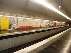
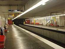 Line 7 platforms at Aubervilliers – Pantin – Quatre Chemins
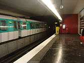 MF 77 rolling stock on Line 7 at Aubervilliers – Pantin – Quatre Chemins
| Wikimedia Commons has media related to Aubervilliers - Pantin - Quatre Chemins (Paris Metro). |
References
- Roland, Gérard (2003). Stations de métro. D’Abbesses à Wagram. Éditions Bonneton.
| Stations |
| ||||||
|---|---|---|---|---|---|---|---|
This article is issued from Wikipedia. The text is licensed under Creative Commons - Attribution - Sharealike. Additional terms may apply for the media files.