Attalla, Alabama
Attalla is a city in Etowah County, Alabama, United States. As of the 2010 census, the population was 6,048.[4]
Attalla | |
|---|---|
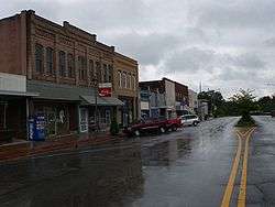 Downtown Attalla | |
| Motto(s): "Gateway to Northeast Alabama"[1] | |
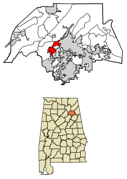 Location of Attalla in Etowah County, Alabama. | |
| Coordinates: 34°0′35″N 86°5′54″W | |
| Country | United States |
| State | Alabama |
| County | Etowah |
| Area | |
| • Total | 6.98 sq mi (18.08 km2) |
| • Land | 6.98 sq mi (18.08 km2) |
| • Water | 0.00 sq mi (0.00 km2) |
| Elevation | 545 ft (166 m) |
| Population (2010) | |
| • Total | 6,048 |
| • Estimate (2019)[3] | 5,771 |
| • Density | 826.79/sq mi (319.21/km2) |
| Time zone | UTC-6 (Central (CST)) |
| • Summer (DST) | UTC-5 (CDT) |
| ZIP code | 35954 |
| Area code(s) | 256 |
| FIPS code | 01-03028 |
| GNIS feature ID | 0157880 |
| Website | www |
History
The town occupies the site of an Indian village which was of considerable importance during the Creek War. It was in Attalla that David Brown, a Cherokee assisted by the Rev. D. S. Butterick, prepared the Cherokee Spelling Book.
Attalla was not founded until 1870, on land donated by W. C. Hammond, a plantation owner. It was incorporated as a city government on February 5, 1872. The town was officially named "Attalla" in 1893, from the Cherokee language word meaning "mountain".[5] Attalla was prosperous until the railroads that it depended on went into bankruptcy.
Attalla is the site of the first hydroelectric dam to provide electricity for a city, constructed in 1887.[6]
20th century to present
William Lewis Moore, a U.S. postman and white civil rights activist, was murdered here on April 23, 1963 as he tried to walk from Chattanooga, Tennessee to Jackson, Mississippi to deliver his letter in support of civil rights to Mississippi Governor Ross Barnett. The suspected murderer, Floyd Simpson, was never charged with the crime.[7]
Geography
Attalla is in Etowah County at 34°0′35″N 86°5′54″W (34.009818, -86.098413).[8] It is bordered to the east by the city of Gadsden, the county seat, and at its southernmost point by Rainbow City.
Interstate 59 runs along the eastern edge of the city, with access from Exits 181 and 183. U.S. Route 11 passes through the center of town as Third Street and runs generally parallel to I-59, leading northeast 36 miles (58 km) to Fort Payne and southwest 58 miles (93 km) to Birmingham. U.S. Routes 278 and 431 also pass through the center of Attalla, leading east 5 miles (8 km) to downtown Gadsden. US 431 runs north 20 miles (32 km) to Albertville, while US 278 leads west 47 miles (76 km) to Cullman. Alabama State Route 77 passes through the southern section of Attalla, leading north 3 miles (5 km) to US 431 and southeast 6 miles (10 km) to Rainbow City.
According to the U.S. Census Bureau, the city has a total area of 7.0 square miles (18.1 km2), all of it land.[4] Big Wills Creek, a tributary of the Coosa River, flows southeasterly through the city. The southern end of Lookout Mountain rises to the east overlooking the city.
Demographics
City of Attalla
| Historical population | |||
|---|---|---|---|
| Census | Pop. | %± | |
| 1880 | 351 | — | |
| 1890 | 1,254 | 257.3% | |
| 1900 | 1,692 | 34.9% | |
| 1910 | 2,513 | 48.5% | |
| 1920 | 3,462 | 37.8% | |
| 1930 | 4,585 | 32.4% | |
| 1940 | 4,885 | 6.5% | |
| 1950 | 7,537 | 54.3% | |
| 1960 | 8,257 | 9.6% | |
| 1970 | 7,510 | −9.0% | |
| 1980 | 7,737 | 3.0% | |
| 1990 | 6,859 | −11.3% | |
| 2000 | 6,592 | −3.9% | |
| 2010 | 6,048 | −8.3% | |
| Est. 2019 | 5,771 | [3] | −4.6% |
| U.S. Decennial Census[9] | |||
2000 Census data
At the 2000 census there were 6,795 people, 2,672 households, and 1,976 families living in the city. The population density was 988.0 people per square mile (381.6/km2). There were 2,914 housing units at an average density of 436.7 per square mile (168.7/km2). The racial makeup of the city was 78.42% White, 13.5% Black or African American, 1.5% Native American, 0.08% Asian, 1.64% from other races, and 0.67% from two or more races. 2.22% of the population were Hispanic or Latino of any race.[10] Of the 2,620 households 30.2% had children under the age of 18 living with them, 47.6% were married couples living together, 16.4% had a female householder with no husband present, and 31.5% were non-families. 29.0% of households were one person and 13.9% were one person aged 65 or older. The average household size was 2.45 and the average family size was 3.00.
The age distribution was 23.7% under the age of 18, 8.9% from 18 to 24, 27.3% from 25 to 44, 22.4% from 45 to 64, and 17.7% 65 or older. The median age was 38 years. For every 100 females, there were 90.2 males. For every 100 females age 18 and over, there were 86.5 males.
The median household income was $27,444 and the median family income was $39,549. Males had a median income of $30,605 versus $19,693 for females. The per capita income for the city was $15,727. About 16.4% of families and 18.6% of the population were below the poverty line, including 22.5% of those under age 18 and 22.0% of those age 65 or over.
2010 census
At the 2010 census there were 6,048 people, 2,442 households, and 1,627 families living in the city. The population density was 983.9 people per square mile (381/km2). There were 2,841 housing units at an average density of 424 per square mile (164.2/km2). The racial makeup of the city was 81.5% White, 12.7% Black or African American, .4% Native American, 0.5% Asian, 2.9% from other races, and 2.0% from two or more races. 4.7% of the population were Hispanic or Latino of any race.[11] Of the 2,442 households 27.0% had children under the age of 18 living with them, 42.5% were married couples living together, 18.1% had a female householder with no husband present, and 33.4% were non-families. 29.8% of households were one person and 13.0% were one person aged 65 or older. The average household size was 2.41 and the average family size was 2.07.
The age distribution was 22.7% under the age of 18, 8.9% from 18 to 24, 25.0% from 25 to 44, 26.3% from 45 to 64, and 17.2% 65 or older. The median age was 39.8 years. For every 100 females, there were 89.3 males. For every 100 females age 18 and over, there were 94.9 males.
The median household income was $32,426 and the median family income was $35,934. Males had a median income of $33,428 versus $25,441 for females. The per capita income for the city was $16,457. About 13.9% of families and 18.2% of the population were below the poverty line, including 27.5% of those under age 18 and 13.9% of those age 65 or over.
Attalla Precinct/Division (1880-1970)
| Historical population | |||
|---|---|---|---|
| Census | Pop. | %± | |
| 1880 | 1,081 | — | |
| 1890 | 1,897 | 75.5% | |
| 1900 | 1,972 | 4.0% | |
| 1910 | 3,337 | 69.2% | |
| 1920 | 4,150 | 24.4% | |
| 1930 | 4,749 | 14.4% | |
| 1940 | 5,227 | 10.1% | |
| 1950 | 7,074 | 35.3% | |
| 1960 | 11,676 | 65.1% | |
| 1970 | 11,166 | −4.4% | |
| U.S. Decennial Census[9] | |||
The Attalla Beat (Etowah County 17th Beat) first appeared on the 1880 U.S. Census. In 1890, "beat" was changed to "precinct." In 1960, the precinct was changed to "census division" as part of a general reorganization of counties.[12] In 1980, Attalla census division was consolidated with Gadsden census division.
Education
The Attalla City School System is the public school district. As of 2006 it has some 1,823 students.[13]
The district includes the following schools:
- Attalla Elementary School (Grades Pk-5)
- Etowah Middle School (Grades 6–8)
- Etowah High School (Grades 9-12)
Notable people
- Gerald William Barrax (1933–2019), poet and educator
- Betty Kelly (born September 16, 1944), member of Motown girl group Martha and the Vandellas
- Larry Means (born April 20, 1947), former member of the Alabama Senate and current mayor
- Patrick Nix (born April 7, 1972), former Auburn University quarterback
- Tyrone Nix (born September 30, 1972), defensive coordinator for the Ole Miss Rebels
- B. L. Noojin (1885–1950), athlete, educator, and politician
- Albert Staton (1899–1980), basketball and football player for Georgia Institute of Technology
- Carnell "Cadillac" Williams (born April 21, 1982), Tampa Bay Buccaneers player
Business and Industries
Photo Gallery
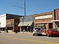 4th Street, Attalla
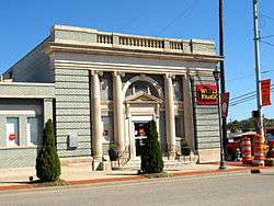 Bank of Attalla
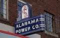 Historic Alabama Power Company sign, Attalla
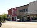 5th Avenue, Attalla
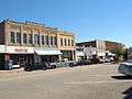 5th Avenue, Attalla
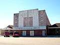 Country Music Opera House, Attalla
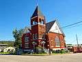 First United Methodist Church, Attalla
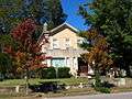 Seven Cedars, Attalla
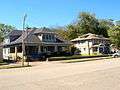 Houses on 5th Avenue, Attalla
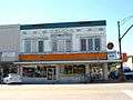 Walker's Drug Store building, Attalla
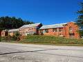 Old Attalla Elementary School
References
Notes
References
- City of Attalla official website
- "2019 U.S. Gazetteer Files". United States Census Bureau. Retrieved June 29, 2020.
- "Population and Housing Unit Estimates". United States Census Bureau. May 24, 2020. Retrieved May 27, 2020.
- "Geographic Identifiers: 2010 Demographic Profile Data (G001): Attalla city, Alabama". American Factfinder. U.S. Census Bureau. Archived from the original on February 13, 2020. Retrieved January 21, 2016.
- "The Names Stayed". Calhoun Times and Gordon County News. August 29, 1990. p. 64. Retrieved 29 April 2015.
- "Historic Attalla Alabama". City of Attalla. Retrieved January 21, 2016.
- "A Postman's 1963 Walk For Justice, Cut Short On An Alabama Road". National Public Radio. Retrieved July 15, 2016.
- "US Gazetteer files: 2010, 2000, and 1990". United States Census Bureau. 2011-02-12. Retrieved 2011-04-23.
- "U.S. Decennial Census". Census.gov. Retrieved June 6, 2013.
- "U.S. Census website". United States Census Bureau. Retrieved 2008-01-31.
- "U.S. Census website". United States Census Bureau. Retrieved 2015-07-23.
- http://www2.census.gov/prod2/decennial/documents/37721510v1p2ch2.pdf, 1960 AL Census
- Attalla City Schools
External links
Municipalities and communities of Etowah County, Alabama, United States | ||
|---|---|---|
| Cities | 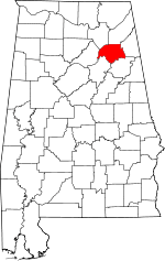 Map of Alabama highlighting Etowah County | |
| Towns | ||
| CDPs | ||
| Unincorporated communities |
| |
| Former City | ||
| Footnotes | ‡This populated place also has portions in an adjacent county or counties | |
| Authority control |
|
|---|