Arkansas Highway 81
Highway 81 (AR 81, Ark. 81, and Hwy. 81) is a north–south state highways in Jefferson County, Arkansas. The highway begins at an intersection with US Highway 65 (US 65) and US 425 and runs 2.29 miles (3.69 km) to US 63/US 79. The designation also includes a spur route, Highway 81 Spur, created in 2005. Both highways are maintained by the Arkansas State Highway and Transportation Department (AHTD).
| ||||
|---|---|---|---|---|
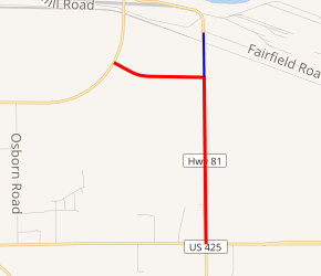
AR 81 in red, AR 81S in blue | ||||
| Route information | ||||
| Maintained by ArDOT | ||||
| Length | 2.29 mi[1] (3.69 km) | |||
| Existed | c. 1945[2]–present | |||
| Major junctions | ||||
| South end | ||||
| North end | ||||
| Location | ||||
| Counties | Jefferson | |||
| Highway system | ||||
| ||||

The Highway 81 designation has also been used for a former highway in Arkansas. A route between Arkansas City and Rohwer held the Highway 81 designation between 1926 and 1929. The designation was reused in 1945 to replace Highway 13 between Louisiana and US 65 east of Pine Bluff (present-day US 425).
Route description
The route begins at an intersection with US 65 and the northern terminus of US 425 just east of Pine Bluff. Highway 81 runs due north as a section line road to an intersection with Highway 81S, when it turns due west. After running briefly west, Highway 81 intersects US 63/US 79 and terminates.[3]
History
Highway 81 was first designated during the 1926 Arkansas state highway numbering in Desha County,[4] but this route was supplanted by Highway 4 in 1929.[5] The designation was revived in 1945, when it supplanted Highway 13 between Louisiana and US 65 in Pine Bluff.[2]
The highway was extended north (along its current routing) to an International Paper plant on February 20, 1957.[6] Other than a realignment for a bypass in Monticello in 1960,[7] the route remained unchanged until November 16, 1988, when the AHTD and the Louisiana Department of Transportation and Development (LADOTD) proposed supplanting Highway 81 and Louisiana Highway 139 with a new route, US 425.[8] This route was approved by the American Association of State Highway and Transportation Officials (AASHTO), renumbering the entire route except the short portion north of US 65 to the paper plant.
Following construction of Lock and Dam No. 4 on the Arkansas River, the Arkansas State Highway Commission desired a connection to the new location Highway 13 (now US 63/US 79, the current northern terminus). An extension of Highway 81 was created on July 13, 1994.[9]
Major intersections
The entire route is in Jefferson County.
| Location | mi[1] | km | Destinations | Notes | |
|---|---|---|---|---|---|
| | 0.00 | 0.00 | Southern terminus | ||
| | 1.47 | 2.37 | AR 81S southern terminus | ||
| | 2.29 | 3.69 | Northern terminus | ||
| 1.000 mi = 1.609 km; 1.000 km = 0.621 mi | |||||
Spur route
| |
|---|---|
| Location | Jefferson County |
| Length | 0.42 mi[1] (0.68 km) |
| Existed | November 9, 2005[10]–present |
Highway 81 Spur (AR 81S, Ark. 81S, and Hwy. 81S) is a spur route of 0.42 miles (0.68 km) in Jefferson County.
Route description
The route begins at Highway 81 east of Pine Bluff and runs due north as a section line road to a paper plant.
History
The route was designated in 2005 from a former alignment of Highway 81 to maintain the paper plant's access to the state highway system.[10]
Major intersections
The entire route is in Jefferson County.
| Location | mi[1] | km | Destinations | Notes | |
|---|---|---|---|---|---|
| | 0.00 | 0.00 | Southern terminus | ||
| | 0.42 | 0.68 | End state maintenance | Northern terminus | |
| 1.000 mi = 1.609 km; 1.000 km = 0.621 mi | |||||
Former route
| |
|---|---|
| Location | Desha County |
| Length | 12 mi (19 km) |
| Existed | April 1, 1926[4]–c. September 1, 1929[5] |
State Road 81 (AR 81, Ark. 81, and Hwy. 81) is a former state highway of in Desha County.
Route description
The route began at State Road 4 in Arkansas City and ran north to State Road 1 near Rohwer.
Major intersections
The entire route was in Desha County.
| Location | mi | km | Destinations | Notes | |
|---|---|---|---|---|---|
| Arkansas City | 0 | 0.0 | Southern terminus | ||
| | 12 | 19 | Northern terminus | ||
| 1.000 mi = 1.609 km; 1.000 km = 0.621 mi | |||||
See also
References
- System Information and Research Division (2014). "Arkansas Road Log Database" (MDB). Arkansas State Highway and Transportation Department. Retrieved March 27, 2016.
- Arkansas State Highway Commission (1945). Map of State Highway System of Arkansas (TIF) (Map). Arkansas State Highway Commission. Retrieved December 14, 2016.
- Transportation Planning and Policy Division (February 17, 2015). General Highway Map, Jefferson County, Arkansas (PDF) (Map). 1:62500. Little Rock: Arkansas State Highway and Transportation Department. Retrieved November 29, 2016.
- Arkansas State Highway Commission (April 1, 1926). Map of the State of Arkansas Showing System of State Highways (TIF) (Map). Arkansas State Highway Commission. Retrieved December 14, 2016.
- Arkansas State Highway Commission (September 1, 1929). Map of State of Arkansas Showing Types of Roads (TIF) (Map). Arkansas State Highway Commission. Retrieved December 14, 2016.
- "Minutes" (1953–69), p. 1739.
- "Minutes" (1953–69), p. 1389-1340.
- "Minutes" (1980–89), p. 1002.
- "Minutes" (1990–99), p. 543.
- "Minutes" (2000–09), p. 821-822.
- "Minutes of the Meeting" (PDF). Arkansas State Highway Commission. 1953–1969. Retrieved December 14, 2016.
- "Minutes of the Meeting" (PDF). Arkansas State Highway Commission. 1970–1979. Retrieved December 14, 2016.
- "Minutes of the Meeting" (PDF). Arkansas State Highway Commission. 1980–1989. Retrieved December 14, 2016.
- "Minutes of the Meeting" (PDF). Arkansas State Highway Commission. 1990–1999. Retrieved December 14, 2016.
- "Minutes of the Meeting" (PDF). Arkansas State Highway Commission. 2000–2009. Retrieved December 14, 2016.
External links
![]()