Arkansas Highway 48
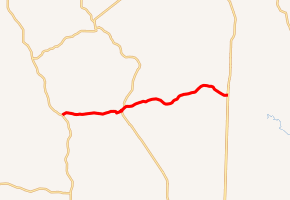
Highway 48 (AR 48, Ark. 48, and Hwy. 48) is an east–west state highway in Southwest Arkansas. The route of 14.53 miles (23.38 km) begins at Highway 9 south of Tulip and runs east to US Highway 167 (US 167) at Ferindale. The route is maintained by the Arkansas State Highway and Transportation Department (AHTD).
| ||||
|---|---|---|---|---|
| ||||
| Route information | ||||
| Maintained by ArDOT | ||||
| Length | 14.53 mi[1] (23.38 km) | |||
| Existed | April 1, 1926[2]–present | |||
| Major junctions | ||||
| West end | ||||
| East end | ||||
| Location | ||||
| Counties | Dallas | |||
| Highway system | ||||
| ||||

Route description
The route begins in northern Dallas County south of Tulip and serves as a lightly-used connection between Highway 9 and US 167, two primary north-south highways in the region. Highway 48 begins at Highway and runs east to Carthage, where it intersects Highway 229, which heads south to Fordyce. Highway 48 and Highway 229 briefly concur eastward until Highway 229 turns north toward Leola. Heading east, the route leaves the city limits and runs through pine forests typical of the Arkansas Timberlands and the Hampton Springs Cemetery, listed on the National Register of Historic Places.[3] Continuing east, Highway 48 terminates at an intersection with US 167 near the Grant County line.[4]
History
Highway 48 was created during the 1926 Arkansas state highway numbering as a route between State Road 9 and US 167. The route has not been altered since creation.[2]
Major intersections
The entire route is in Dallas County.
| Location | mi[1] | km | Destinations | Notes | |
|---|---|---|---|---|---|
| | 0.00 | 0.00 | Western terminus | ||
| Carthage | 4.89 | 7.87 | Western end of AR 229 concurrency | ||
| 5.29 | 8.51 | Eastern end of AR 229 concurrency | |||
| Ferindale | 14.53 | 23.38 | Eastern terminus | ||
1.000 mi = 1.609 km; 1.000 km = 0.621 mi
| |||||
See also
References
- System Information and Research Division (2014). "Arkansas Road Log Database" (MDB). Arkansas State Highway and Transportation Department. Retrieved March 27, 2016.
- Arkansas State Highway Commission (April 1, 1926). Map of the State of Arkansas Showing System of State Highways (TIF) (Map). Arkansas State Highway Commission. Retrieved November 18, 2016.
- "National Register Information System". National Register of Historic Places. National Park Service. July 9, 2010.
- Arkansas State Highway and Transportation Department (December 12, 2013). General Highway Map, Dallas County, Arkansas (PDF) (Map). 1:62500. Arkansas State Highway and Transportation Department. Retrieved November 18, 2016.
External links
![]()