Utsjoki
Utsjoki (North Sami: Ohcejohka) is the main village of the municipality with the same name, in northernmost Finnish Lapland. It is located beside the Teno river (Norwegian: Tana, Sámi: Deatnu) and the border to Norway.
Understand

The municipality is very sparsely populated, with large wilderness areas. About half the population is Sami. Reindeer husbandry is important both culturally and economically. The border trade with Norway is important and social ties across the border common.
- Áilegas centre, Utsjoentie 46 c, ☎ +358 40-667-2229. Culture centre, with exhibitions, courses etc. Also the tourist office and the Metsähallitus information point.
- Tourist information, ☎ +358 40-181-0263.
- Utsjoki nature information point, ☎ +358 20-639-7792, e-mail: utsjoki@metsa.fi. 2017: 15.6–15.9 M–F 10:00–17:00, wintertime closed. Information on hiking in the Kevo reserve and the Paistunturi and Kaldoaivi wilderness areas; sales of publications, maps and fishing permits for the areas. Free.
Get in
The normal way to get to Utsjoki is using the roads; either driving or travelling with the bus (timetables by Matkahuolto). Snowmobile routes and hiking trails provide alternatives for the more adventurous. Remember that distances are huge.
The European routes E6 and E75 meet across the border in Norway. The former travels through Norway all the way from Halden in the south to Kirkenes in the east, the latter runs through Finland via Rovaniemi, Ivalo and Inari to Utsjoki and across the bridge to Norway.
The nearest airports are Ivalo (170 km), Kittilä (320 km) and Rovaniemi (450 km) in Finland, and Lakselv (190 km) and Kirkenes (190 km) in Norway. Ivalo has daily connections to Helsinki.
There are daily coaches from Rovaniemi via Ivalo, Kaamanen, Utsjoki and Nuorgam to Tana Bru (and Vadsø in summer). There are also daily minibuses from the Norwegian side (the place is called Roavvegieddi) to Karasjok and Varangerbotn (must be prebooked, timetables by Snelandia).
Get around
The village itself is small, but it is stretched out along the rivers, such that you have to like walking and have some time to manage without vehicles (6 km from the tourist information to the church).
You can use daily long distance coach services from Rovaniemi for destinations along E75 and possibly school buses along the other roads. Taxis are probably the most practical solution for anything farther than you want to walk. A bike is usable in summer if you have or can rent one.
The national roads are in good shape, built as straight lines through the wilderness. Minor roads may be in less good condition, especially in the winter, spring and early summer.
In the winter there are snowmobile routes, which can be used also for longer journeys. Driving outside routes is forbidden, with some exceptions.
See
- The panorama of the Teno river.
- Northern Lights – Except of the summer time, when nights are light in Lapland, chances are good you'll be amazed by colourful curtains of Aurora borealis silently dancing high above you.
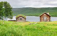
- Utsjoki church (by Lake Mantojärvi, near E75, some 6 km south from Utsjoki). Church built 1850–1853 at the site of one from 1700, parsonage from 1843. By the church is the old courthouse and huts for Sámi arriving from far away.

Do
- Hiking in the surroundings, the Kevo Strict Nature Reserve or the Paistunturit or Kaldoaivi Wilderness Area. Information from Utsjoki nature information point (in summer) or Siida in Inari. Several trails start from the information point.
- Utsjoki geological trail (3.5 km)
- Kalkujoenlampi Trail (5.9 km circle trail)
- Utsjoki Hiking Trail (35 km as circle trail), mostly above the tree line in open fell areas, via Mantojärvi Church. The highest point along the trail, Roavveoaivi (466 m), offers wide views, e.g. to the snowcapped Rastigaissa fell in Norway
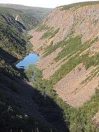
- Kevo Hiking Trail (64 km) through the Kevo canyon in the Kevo strict nature reserve to Sulaoja near Karigasniemi
- Elli Trail (3.8 km), starts from the intersection at Lomatärppi holiday village
- Cross-country skiing in the wilderness areas in winter, challenging even for experienced skiers because of the sometimes very harsh conditions
- Salmon fishing in the Teno river, the most important salmon river in Europe. As in salmon rivers elsewhere, this requires an easy to buy special permit in addition to the national fishing management fee. Check procedures for disinfecting equipment, note Norwegian requirements if crossing the border
Buy
People coming from the Norwegian side of the border usually head for the Alko store in Nuorgam to buy liquor, because it's far cheaper than in Norway.
Tourists from elsewhere will most probably find some souvenirs more interesting.
Eat
- 🌍 Restaurant Deatnu, Ellintie 25, 99980 Utsjoki, ☎ +358 400 948 210, e-mail: info@holidayvillagevalle.fi. Weekdays 11:00-22:00, weekend 16:00-22:00.
Drink
Sleep
- Camping Lapinkylä (300 m from Utsjoki centre), ☎ +358 40-559-1542. Open June–September. Café. Fishing trips, fishing licences, fishing equipment rental, salmon weighting, boat rental. Willow grouse hunting trips in autumn and spring, with accommodation at the wilderness areas. Cabin €50–70, caravan €20 (storage €2/day), tent €12.
Go next
- Other village in the municipality:
- Nuorgam, some 50 km north-east from Utsjoki, the very northernmost point of Finland – and of the European Union
- Karigasniemi (Sami: Gáregasnjárga) in the south-west, on the way to Karasjok, Kautokeino and Alta. Road 970 along Teno to Karigasniemi provides for a scenic ride, while most buses use E75 to Kaamanen and road 92 onward.
- Norway is just across the bridge over Teno. The municipality Tana has its centre downstream at Tana bru ("Tana bridge"), which got its bridge already in 1948.
| Routes through Utsjoki |
| Kirkenes ← Tana ← | N |
→ Karasjok → Narvik |
| Vardø ← Tana ← | N |
→ Inari → Rovaniemi |