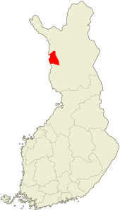
Kolari
Kolari is a municipality in Finnish Lapland, best known as the northernmost railhead in Finland, with overnight trains from southern Finland. Most tourists continue from the town itself to Ylläs or other resorts.

Understand
Yllästunturi (Ylläs fell) by Pallas-Yllästunturi National Park 35 km away is the most important tourist destination nearby. Otherwise the municipality is largely forest and swamps (including an important bird site) with some fells in the west.
Get in
The municipality, at the Swedish border (by Pajala), has one of the northern railheads, with overnight trains from southern Finland.
By plane
The nearest airports are in Kittilä to the east and in Pajala across the border to Sweden. Rovaniemi, farther away but with better connections at least off season, is another option.
By train
Kolari is the northernmost train station in Finland. During the winter season there is a direct train connection daily from Helsinki via Tampere; at 995 kilometers, this is the longest single train route in Finland. An overnight trip takes 13 hours and is most comfortable in a sleeping cabin. Sometimes the train contains a special club car serving as a nightclub during the trip.
By car
From Helsinki, drive by E75 to the north. Switch to E8 after Kemi.
From Sweden there are bridges e.g. at Haparanda/Tornio, Övertorneå/Ylitornio (Aavasaksa), Pello and Pajala/Kolari
From northern Norway use E8 from Tromsø, road 93 via Kautokeino or E75 via Tana. From E75 you can turn at Sodankylä and continue via Kittilä.
Get around
The town is mostly built along the Muonionjoki river and its Saaripudas fork. The 🌍 train station is in the north end. The Kolari and Kolarinsaari churches are some 3 km downstream, the latter across the Kolarinsaari bridge. The 🌍 bridge over Muonionjoki is 3 km further downstream, in the south end of the town, 25 km from Pajala centre.
The island Kolarinsaari is some 7 km long, sparsely settled near the bridge in the south. The settlements in the north are adjacent to Saaripudas on the Finnish side and the Swedish Kolari village (there was no border here before the 19th century).
See
Do
- Lukkarinvainio nature trail starting from the Kolarinsaari church (3,5 km)
- Snowmobiling; a day hut, lean-to shelters and similar service along the route not far away, the routes extend to most of Lapland.
- 🌍 Teuravuoma-Kivijärvenvuoma Protected Mire Area (8 km to the east along Kurtakontie, road 80, then 3.7 km along the road to Teurajärvi, to the right). Three aapa mire complexes, including open fens and forested pine bogs and spruce swamps (58 km²). One of the best bird watching sites in central Lapland. Easy routes with duckboards, lean-to shelters, campfire sites and observation towers. The observation tower at Teurajärvi, 1.4 km from the road, gives a very nice view. Kurtakko, another trailhead near Kurtakontie (1.5 km), is a 13 km hike away (i.e. 16 km in all with public transportation). Get mosquito repellent.
Buy
- 🌍 Wood jewel, Jokijalantie 1 (by E8), ☎ +358 50-366-8980, e-mail: kauko.raatiniemi@pp.inet.fi. Knives, fishing lures and souvenirs, including wooden jewellery. Café with lunch.
Eat
Drink
Sleep
- 🌍 Hotel Kolari, Muoniontie 1 (360 m from the train station), ☎ +358 16 313 711. Breakfast included. Sauna. Free Wi-Fi. Social dancing with live music about weekly. single €85, double €105.
Connect
- 🌍 Library, Isopalontie 2, ☎ +358 40-489-5014, e-mail: kolari.kirjasto(at)kolari.fi. M-Th 11–19, F 10–17, Sa 10–15. Also computers and Wi-Fi.
Go next
- Ylläs or Äkäslompolo, ski resorts, also usable as a base for hikes.
- Pallas-Yllästunturi National Park, the most visited national park in Finnish Lapland, with an old hiking trail to Hetta and well-developed services.
| Routes through Kolari |
| Tromsø ← Karesuvanto ← | W |
→ Tornio → Turku |