Enontekiö
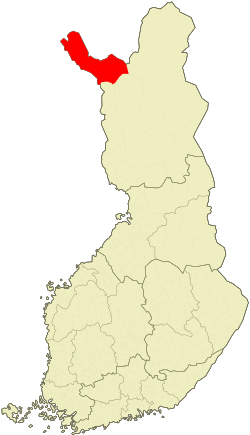
Enontekiö (Sami: Eanodat or Iänudâh, Swedish: Enontekis) is a large sparsely populated municipality in the north-western arm of Finnish Lapland. The municipality contains part of Pallas-Yllästunturi National Park, a number of designated wilderness areas as well as all peaks of more than 1000 meters in Finland, among them the highest peak Halti at 1,324 m (4,344 ft) above sea level. Enontekiö has the second lowest population density in Finland, with less than 2,000 people on more than 8,000 km² (3,000 sq mi). Wide areas lie above the tree line.
- Enontekiö Tourist Information, ☎ +358 400-556-215, e-mail: info.matkailu@enontekio.fi.

Villages
- 🌍 Hetta (Sami: Heahttá) – Hetta is the main village and administrative centre of the municipality so the names Hetta and Enontekiö are used interchangeably.
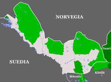
- 🌍 Kilpisjärvi (Sami: Gilbbesjávri) – The northernmost village of Enontekiö is the location of Sana fell and a great starting point for a trip to Halti. Tripoint with Sweden and Norway in Malla Nature Reserve.
- 🌍 Karesuvanto (Sami: Gárasavvon, Swedish: Karesuando) – the main border crossing in Enontekiö between Sweden and Finland
Other destinations
- 🌍 Pallas-Yllästunturi National Park
- 🌍 Käsivarsi Wilderness Area
- Pulju Wilderness Area
- 🌍 Pöyrisjärvi Wilderness Area
- Tarvantovaara Wilderness Area (see Karesuvanto)
Get in
By plane
Enontekiö airport is 6 km west of the main village of Hetta. It is only served by Flybe airlines during spring, but numerous charter flights land throughout the winter. There are no air services during the summer months due to poor demand.
Kittilä Airport between Kittilä and Levi, 150 km south by road, is probably the next nearest airport within easy reach of Hetta. A bus service connects Kittilä to Hetta (see below)
Alta Airport in the northern Norwegian town of Alta is 200 km north by road. Bus connections between Alta and Hetta are possible but more complicated.
By car
Usually people arrive to Enontekiö by car, either from the south or from the neighbouring countries, Norway and Sweden. From Norway you usually enter through the border town of Kilpisjärvi by European route E8, further east via Kautokeino and Kivilompolo by road 93, or through Sweden. From Sweden there are several crossings south of Hetta and Karesuando/Karesuvanto to the west.
Cars are available for rent, if booked in advance, at most major airports, including Alta and Kittila. There are limited rental car services in Hetta, mainly run by local entrepreneurs – if you want to rent a car in Hetta it is best to ask for details at your hotel. Demand is low, so there is no need to pre-book; journeys must conclude in Hetta. Cars can also be taken on the trains from southern Finland.
It is possible to get someone to drive your car to where you need it. Ask at your hotel.
By train
The Finnish rail network terminates over 300 km to the south in Rovaniemi and Kolari. Swedish trains from the south go to Luleå and Boden, and along Malmbanan from there via Kiruna to Narvik in Norway.
An overnight train allows you to have a good rest before continuing by bus or car.
By bus
Up here in the north, the bus network is the next best way to get around. There are a number of routes north from Rovaniemi, the most import of which is Rovaniemi–Hetta service, which operates twice daily. This service connects Rovaniemi via Kittilä Airport, the ski resorts of Levi and Olos, Muonio and finally Hetta, with various stops in-between. Matkahuolto releases bus schedules for September–May and May–August. The journey from Rovaniemi to Hetta takes around 4hr 50min, and the journey from Kittilä to Hetta takes around 2hr 30min.
From northernmost Sweden, take the bus to Karesuando and walk across the border.
In winter connections from Norway are cumbersome, via Sweden or via Inari.
The Swedish bus service Lanstrafiken Norrbotten Busses provides a service from Alta to Kautokeino. From Kautokeino you can take a bus across the border to Finland with Eskelisen Lapin Linjat to Hetta, but only during the summer months, June–August.
In summer there is also a service by Eskelisen Lapin Linjat between Tromsø in Norway and Rovaniemi, via Kilpisjärvi, which can be used also to reach Hetta (with quite a long wait at Palojoensuu).
By bike
The Eurovelo cycling route nr 7 from Nordkapp to Malta ("Sun Route", 7,409 km) comes down trough Finnmarksvidda, passes Hetta and continues down through Sweden. There are no biking lanes or other special arrangements for bikers up here, so there is no big advantage of the Eurovelo route, but there may be more information and tips on it than on the other options – and usually there is just one road to choose from.
Distances are huge but the hills are not very steep, the roads are mostly well maintained and traffic is light. Mind your clothing – even in July average temperatures are around 10°C (50°F) in some parts of the municipality.
The coaches usually take bikes, so you can choose what legs to go on your own.
Get around
Practically there are three forms of transport in these parts of Finland: your own car, taxi and coach. Coaches run one or two times every day from Rovaniemi. Bikes are useful in the summer and can be taken on the bus. In the winter there is a network of snowmobile routes and snowmobile tracks.
There is a system with taxis driving on request by bus fare along certain routes around the municipality ("kutsutaksi"). These are primary meant for elderly inhabitants of small villages needing to visit Hetta once in a while, but are open to anyone. They mostly drive weekly and must be requested before 18:00 the preceding evening. Check these if ordinary buses do not seem to fit and you do not want to use normal taxis. With some luck they may allow a chat giving insight in local life in quite an other way than using tourist facilities.
There is also transport from the airports (still valid?).
Then of course, trekking is one of the reasons to come here. There is lot of nature to be explored by foot, ski, bike, canoe or similar means. Snowmobiles can also be rented (but are restricted to waterways and marked routes, some of which require paying a fee).
See

Views and nature.
- 🌍 Järämä WWII Fortification Camp (Järämän linnoitusalue), Käsivarrentie 5465, 99470 Karesuvanto (Drive the main road number 21/E8, about 20 km from Karesuvanto village, in the direction of Kilpisjärvi.), ☎ +358 400 556 215. Järämä renovated fortification camp, known as Sturmbock-Stellung to the Germans, is located in Enontekiö municipality, in the north-west of Lapland. Originally it was built by Germans and is just one part of a larger network of fortification camps, built during the Lapland War, to protect the harbours of the Arctic Ocean. The camp is dug partly into the bedrock. No real battles were ever fought in this fortification camp.
Do
- Hiking, cross country skiing, whitewater sports etc.
- Skiing
- Maintained slopes in Hetta
- Maintained cross-country tracks in Hetta, the national park and Kilpisjärvi.
- For ski touring off tracks the national park and any of the wilderness areas provide ample terrain. Most mountains are in Käsivarsi Wilderness Area. Make sure you know what you are doing.
- Snowmobile and husky safaris, fishing and polar light watching trips and other programme services at most tourist businesses.
- Käsivarren Luontopalvelut, Saharannantie 66, ☎ +358 40 589 1940. Program services
Buy
Shops in Hetta, Kilpisjärvi and at some other locations. For souvenirs, check in advance. The park visitor centres have some, but most shops have mostly kitsch, if even that. There are artists, but many work from home and sell mostly from there, on the net and in design shops elsewhere.
Eat
Reindeer and fish usually feature on most menus. Food is expensive in this part of Finland, so expect to see this reflected in menu prices. Quite limited options.
Drink
Sleep
See Hetta, Kilpisjärvi and Pallas-Yllästunturi National Park
Go next
See the neighbouring countries Sweden and Norway. Especially road to Skibotn in Norway has incredible canyon sights.