Zephyrhills, Florida
Zephyrhills is a city in Pasco County, Florida, United States. The population was estimated at 13,288 in the 2010 census. It is a suburb of the Tampa Bay Metropolitan Statistical Area. Zephyrhills is also known as the headquarters of the Zephyrhills bottled water company and is a member of Tree City USA.
The City of Zephyrhills | |
|---|---|
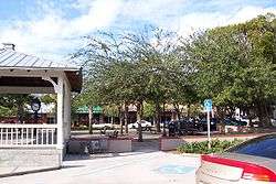
 5th Avenue in the Zephyrhills Downtown Historic District | |
| Nickname(s): Z-hills | |
| Motto(s): "City of pure water" | |
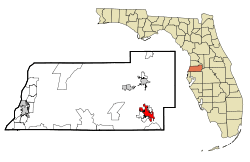
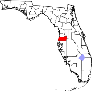
 Location in Pasco County and the state of Florida | |
| Coordinates: 28°14′14″N 82°10′46″W | |
| Country | United States |
| State | Florida |
| County | Pasco |
| Settled | April 18, 1888 |
| Incorporated (town) | 1910 |
| Incorporated (city) | 1914 |
| Government | |
| • Mayor | Gene Whitfield |
| • City Manager | Steve Spina |
| • City Clerk | Lori Hillman |
| Area | |
| • Total | 9.53 sq mi (24.67 km2) |
| • Land | 9.47 sq mi (24.53 km2) |
| • Water | 0.05 sq mi (0.14 km2) |
| Elevation | 95 ft (29 m) |
| Population (2010) | |
| • Total | 13,288 |
| • Estimate (2019)[2] | 16,456 |
| • Density | 1,737.33/sq mi (670.77/km2) |
| Time zone | UTC-5 (Eastern (EST)) |
| • Summer (DST) | UTC-4 (EDT) |
| ZIP codes | 33539–33544 |
| Area code(s) | 813 |
| FIPS code | 12-79225[3] |
| GNIS feature ID | 0293620[4] |
| Website | www |
History
Zephyrhills began as the town of Abbott on April 18,1888 and consisted of 280.74 acres. A voting district was established in 1893 followed by a post office in 1896. In 1909, Captain Harold B. Jeffries, a Civil War Union veteran from Pennsylvania purchased 35,000 acres and created the Zephyrhills Colony Company with a plan to create a community for Civil War veterans.[5] In 1910 the town voted to change its name to Zephyrhills; it was incorporated in 1914.[6]
In 1941, one resident reported that Zephyrhills had a sundown town policy forbidding African Americans from living within the city limits.[7]
The city created a historic district in 1999; in 2001 the Zephyrhills Historic District was nominated for and listed on the National Register of Historic Places.[6] A Founders Day celebration is held annually in March.[8]
Demographics
| Historical population | |||
|---|---|---|---|
| Census | Pop. | %± | |
| 1920 | 577 | — | |
| 1930 | 748 | 29.6% | |
| 1940 | 1,252 | 67.4% | |
| 1950 | 1,826 | 45.8% | |
| 1960 | 2,887 | 58.1% | |
| 1970 | 3,369 | 16.7% | |
| 1980 | 5,742 | 70.4% | |
| 1990 | 8,220 | 43.2% | |
| 2000 | 10,833 | 31.8% | |
| 2010 | 13,288 | 22.7% | |
| Est. 2019 | 16,456 | [2] | 23.8% |
| U.S. Decennial Census[9] | |||
2000 census
As of the 2000 United States Census, there were 10,833 people and 2,986 families in the city. The population density was 1,728.2 inhabitants per square mile (667.1/km2). There were 6,167 housing units at an average density of 983.8 per square mile (379.8/km2). The racial makeup of the city was 92.63% White, 2.79% African American, 0.23% Native American, 1.12% Asian, 0.03% Pacific Islander, 1.60% from other races, and 1.61% from two or more races. Hispanic or Latino of any race were 5.03% of the population.
There were 4,944 households out of which 20.5% had children under the age of 18 living with them. 46.5% were married couples living with others, 10.5% had a female householder with no husband present, and 39.6% were non-families. 34.3% of all households were made up of individuals and 19.2% had someone living alone who was 65 years of age or older. The average household size was 2.10 and the average family size was 2.63.
The population contained 18.1% under the age of 18, 6.5% from 18 to 24, 21.2% from 25 to 44, 21.4% from 45 to 64, and 44.8% who were 65 years of age or older. The median age was 49 years. For every 100 females, there were 83.4 males. For every 100 females age 18 and over, there were 79.4 males.
The median income for a household in the city in 2005 was $33,100,[10] and the median income for a family was $33,502. Males had a median income of $29,375 versus $21,648 for females. The per capita income for the city was $18,047. About 9.3% of families and 12.1% of the population were below the poverty line, including 15.9% of those under age 18 and 9.6% of those age 65 or over.
Transport
Major roads


Public transportation
Zephyrhills is served by Pasco County Public Transportation on routes #30, #33, and #54.[11]
Train Wreck 2004
In the early morning hours of November 29, 2004, CSX Train Q441 Pulled by Dash 8-40CW #7803 & SD70M #4695, collided head on into CSX Train K916 pulled by SD40-2 #8101 & SD70MAC #4810. 7803 & 8101 were totaled and scrapped in between late 2004 and early 2005. 4695 & 4810 were repaired and are still in service today. The cause of the accident was because K916 ran a red signal in the fog.
Airport
The city is served by Zephyrhills Municipal Airport. It was also once served by the 1927-built Zephyrhills Depot on the Atlantic Coast Line, which is now the Zephyrhills Depot Museum at a city park near the airport. More than 70,000 skydives are performed annually on the airport at Skydive City, Inc., the largest woman-owned drop zone in the world, founded in 1990 by Joannie Murphy and Susan Perkins Stark.
Public library
The Zephyrhills Public Library was founded in 1912. According to the city's website, "The Library provides open and equal access to the resources and services of the library. The Library seeks to encourage reading and the use of technology for life-long learning and the enhancement of the community's quality of life."[12] Library personnel also staff the City‟s Depot Museum. The library is managed by a Library Advisory Board and is a member of the Pasco County Library Cooperative. A new library was built in 2014 just north of the old library.
The Zephyrhills Depot Museum originated with the 1989 purchase of the 1927 Atlantic Coast Line Depot from CSX Railroad by the City of Zephyrhills. The original depot was relocated 200 feet (61 m) west of its original location. Restoration of the 2,700 square feet (250 m2) building began in 1997 with a Grant from the State Department of Transportation. The Historical Preservation Committee and the Zephyrhills Historical Association worked together to complete the restoration. The Zephyrhills Depot Museum opened on 20 October 1998.
Public safety
The Zephyrhills Police Department consists of about 35 officers. The current chief of police is Derek Brewer.[13][14][15] The Zephyrhills Fire Department consists of career and volunteer firefighters.[16][17]
The State of Florida Department of Corrections maintains the Zephyrhills Correctional Facility one mile south of the city limits. The prison population is adult males, with a capacity of over 700 inmates.[18]
Notable people
- Domonic Brown, baseball player
- Dave Eiland, former major league pitcher
- Prince Iaukea, pro wrestler (born Michael Hayner)
- Ramiele Malubay, American Idol finalist (attended Zephyrhills High School until 2002)
- Jessica Meuse, American Idol finalist, briefly lived in Zephyrhills
- Tracy Negoshian, fashion designer
- Stephen Perry, writer for the animated series ThunderCats and Silverhawks
- Ryan Pickett, defensive tackle for the Green Bay Packers, graduated from Zephyrhills High School in 1998
- Buzzie Reutimann, race car driver
- David Reutimann, NASCAR Sprint Cup Series driver
- Carl Tanzler (aka Carl von Cosel), famous for stealing and preserving the corpse of Elena Milagro Hoyos
- Peta Jensen, adult film actress
Geography
Climate
The climate in this area is characterized by hot, humid summers and warm, generally dry winters. According to the Köppen Climate Classification system, Zephyrhills has a humid subtropical climate, abbreviated "Cfa" on climate maps.[19]
| Climate data for Zephyrhills, Florida | |||||||||||||
|---|---|---|---|---|---|---|---|---|---|---|---|---|---|
| Month | Jan | Feb | Mar | Apr | May | Jun | Jul | Aug | Sep | Oct | Nov | Dec | Year |
| Record high °F (°C) | 87 (31) |
90 (32) |
94 (34) |
98 (37) |
102 (39) |
103 (39) |
101 (38) |
99 (37) |
98 (37) |
96 (36) |
92 (33) |
88 (31) |
103 (39) |
| Average high °F (°C) | 72 (22) |
75 (24) |
79 (26) |
84 (29) |
89 (32) |
92 (33) |
92 (33) |
92 (33) |
91 (33) |
85 (29) |
79 (26) |
74 (23) |
84 (29) |
| Average low °F (°C) | 48 (9) |
50 (10) |
54 (12) |
58 (14) |
64 (18) |
70 (21) |
72 (22) |
72 (22) |
70 (21) |
63 (17) |
56 (13) |
50 (10) |
61 (16) |
| Record low °F (°C) | 18 (−8) |
16 (−9) |
24 (−4) |
38 (3) |
46 (8) |
54 (12) |
64 (18) |
62 (17) |
53 (12) |
39 (4) |
27 (−3) |
18 (−8) |
16 (−9) |
| Average precipitation inches (mm) | 3.41 (87) |
3.38 (86) |
4.06 (103) |
2.35 (60) |
3.89 (99) |
7.13 (181) |
7.69 (195) |
7.47 (190) |
6.54 (166) |
2.75 (70) |
2.52 (64) |
2.65 (67) |
53.84 (1,368) |
| Source: [20] | |||||||||||||
References
- "2019 U.S. Gazetteer Files". United States Census Bureau. Retrieved July 2, 2020.
- "Population and Housing Unit Estimates". United States Census Bureau. May 24, 2020. Retrieved May 27, 2020.
- "U.S. Census website". United States Census Bureau. Retrieved 2008-01-31.
- "US Board on Geographic Names". United States Geological Survey. 2007-10-25. Retrieved 2008-01-31.
- Blackstone, Lillian (23 March 1952). "Into center of state". St. Petersburg Times. p. 19. Retrieved 1 November 2015.
- Historic Home Tour/City History (accessed 10 April 2020)
- "Down in Florida". Marengo Republican-News. Marengo, Illinois. 23 January 1941. p. 1 – via Newspapers.com.
'Believe it or not, we have 'black-outs' here. Negroes are not allowed to live in the city. They must live either in the country or on the R.-R. right-of-way.'
- Founders Day Library of Congress
- "Census of Population and Housing". Census.gov. Retrieved 4 June 2015.
- "Zephyrhills, Florida (FL 33540) profile: population, maps, real estate, averages, homes, statistics, relocation, travel, jobs, hospitals, schools, crime, moving, houses, news, sex offenders". www.city-data.com.
- "Archived copy". Archived from the original on 24 July 2013. Retrieved 26 November 2013.CS1 maint: archived copy as title (link)
- "Library"
- "Chief of Police | Zephyrhills, FL". ci.zephyrhills.fl.us. City of Zephyrhills. Retrieved 28 February 2020.
- "Police Department | Zephyrhills, FL". City of Zephyrhills. Retrieved 28 February 2020.
- "Zephyrhills Police Department". City of Zephyrhills. Archived from the original on 10 August 2010. Retrieved 31 July 2010.
- "Fire Department | Zephyrhills, FL". ci.zephyrhills.fl.us. City of Zephyrhills. Retrieved 28 February 2020.
- "Fire Chief's Office". City of Zephyrhills. Archived from the original on 5 May 2010. Retrieved 31 July 2010.
- http://www.dc.state.fl.us/ci/573.html
- "Zephyrhills, Florida Köppen Climate Classification (Weatherbase)". Weatherbase.
- "Historical Averages for Zephyrhills FL". Retrieved 10 May 2015.
Further reading
- Harrison, Benjamin (1997). Undying Love - The Shocking True Story of a Passion That Defied Death. St. Martin's. ISBN 0-312-97802-2.
- Trottman, Rosemary W. (1978). The History of Zephyrhills, 1821-1921. Vantage Press. ISBN 0-533-02882-5.
- Wise, Madonna Jervis (2008). Tapestry-Zephyrhills: An Anthology of Its History Through Education. BookSurge Publishing. ISBN 978-1-4196-9640-4.
- Wise, Madonna Jervis (2010). Zephyrhills (Images of America). Arcadia Publishing. ISBN 978-0-7385-6676-4.
External links
| Wikimedia Commons has media related to Zephyrhills, Florida. |


