Zahedan
Zahedan (Balochi and Persian: ![]()
Zahedan زاهدان | |
|---|---|
City | |
 | |
 Seal | |
 Zahedan | |
| Coordinates: 29°29′47″N 60°51′46″E | |
| Country | |
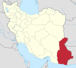
| Province | Sistan and Baluchestan |
| County | Zahedan |
| Bakhsh | Central |
| Government | |
| Elevation | 1,352 m (4,436 ft) |
| Population (2016 Census) | |
| • Urban | 587,730[1] |
| Time zone | UTC+3:30 (IRST) |
| • Summer (DST) | UTC+4:30 (IRDT) |
| Area code(s) | +98-54 |
| Climate | BWh |
| Website | zahedan |
Etymology
Zâhedân (زاهدان) derives from the plural of the Persian word zâhid (زاهد), meaning 'pious'.
Geography
Zahedan is located near Pakistan and Afghanistan, only about 41 km (25 mi) south of the tripoint of the borders of the three countries, at an altitude of 1,352 m (4,436 ft) above sea level and at a distance of 1,605 km (997 mi) from the Iranian capital of Tehran.
Climate
Zahedan has a hot desert climate (Köppen climate classification BWh) with hot summers and cool winters. Precipitation is very low, and mostly falls in winter.
| Climate data for Zahedan | |||||||||||||
|---|---|---|---|---|---|---|---|---|---|---|---|---|---|
| Month | Jan | Feb | Mar | Apr | May | Jun | Jul | Aug | Sep | Oct | Nov | Dec | Year |
| Record high °C (°F) | 27.0 (80.6) |
28.0 (82.4) |
32.2 (90.0) |
37.0 (98.6) |
40.4 (104.7) |
43.0 (109.4) |
42.0 (107.6) |
43.0 (109.4) |
40.0 (104.0) |
36.0 (96.8) |
30.2 (86.4) |
28.0 (82.4) |
43.0 (109.4) |
| Average high °C (°F) | 14.0 (57.2) |
16.5 (61.7) |
21.9 (71.4) |
27.5 (81.5) |
32.5 (90.5) |
36.2 (97.2) |
37.0 (98.6) |
35.6 (96.1) |
32.3 (90.1) |
27.7 (81.9) |
21.7 (71.1) |
16.3 (61.3) |
26.6 (79.9) |
| Daily mean °C (°F) | 6.4 (43.5) |
9.2 (48.6) |
14.5 (58.1) |
20.0 (68.0) |
24.7 (76.5) |
28.3 (82.9) |
29.3 (84.7) |
27.1 (80.8) |
22.7 (72.9) |
17.8 (64.0) |
11.9 (53.4) |
7.9 (46.2) |
18.3 (65.0) |
| Average low °C (°F) | −0.5 (31.1) |
2.5 (36.5) |
7.4 (45.3) |
12.1 (53.8) |
15.9 (60.6) |
18.6 (65.5) |
19.8 (67.6) |
17.2 (63.0) |
12.4 (54.3) |
8.1 (46.6) |
3.1 (37.6) |
0.5 (32.9) |
9.8 (49.6) |
| Record low °C (°F) | −22 (−8) |
−14 (7) |
−7 (19) |
0.0 (32.0) |
1.4 (34.5) |
11.0 (51.8) |
12.0 (53.6) |
8.0 (46.4) |
2.0 (35.6) |
−4 (25) |
−11 (12) |
−16 (3) |
−22 (−8) |
| Average precipitation mm (inches) | 19.3 (0.76) |
21.1 (0.83) |
13.6 (0.54) |
9.5 (0.37) |
3.9 (0.15) |
0.4 (0.02) |
0.8 (0.03) |
0.9 (0.04) |
0.2 (0.01) |
1.8 (0.07) |
3.4 (0.13) |
7.2 (0.28) |
82.1 (3.23) |
| Average rainy days | 4.3 | 4.5 | 4.2 | 4.2 | 2.4 | 0.3 | 0.4 | 0.2 | 0.3 | 0.9 | 1.3 | 2.8 | 25.8 |
| Average snowy days | 0.7 | 0.4 | 0.1 | 0 | 0 | 0 | 0 | 0 | 0 | 0 | 0 | 0.3 | 1.5 |
| Average relative humidity (%) | 54 | 50 | 42 | 36 | 29 | 24 | 23 | 24 | 25 | 31 | 40 | 49 | 36 |
| Mean monthly sunshine hours | 208.8 | 199.3 | 221.2 | 235.2 | 296.2 | 310.2 | 317.9 | 324.5 | 305.4 | 290.2 | 245.6 | 215.2 | 3,169.7 |
| Source: NOAA (1961–1990) [4] | |||||||||||||
Education
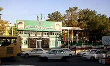
Zahedan is the home of the Islamic Azad University of Zahedan,[5] the Zahedan University of Medical Sciences[6] and the University of Sistan and Baluchestan. Besides, the largest Sunni seminary, Darululoom Zahedan, is located in Zahedan. There are some other religious Sunni schools in the city and the vicinity.
History, culture and demographics
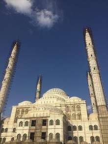
_Mosque.jpg)
The demographics of Zahedan's inhabitants are largely ethnic Baloch who speak the Balochi language and Sistanis who speak various dialects of Persian language such as Sistani, Yazdi and Khorasani. There are also smaller numbers of Pashtuns and Kurds.
Zahedan lies east of the Kavir-e Loot desert. The city was part of the historic region of Sistan (Persian: سیستان), situated today on the borders of southeastern Iran and southwestern Afghanistan. One portion is part of the Iranian province of Sistan and Baluchestan. The other portion is part of the Nimruz Province of Afghanistan.
The name Sistan comes from 'Sakastan', of which Sistan was once the westernmost part. The Saffarids (861–1003 CE), one of the early Iranian dynasties of the Islamic era, were originally rulers of Sistan. In the Shahnameh, Sistan is also referred to as Zabulistan, after Zabol, a city in the region. In Ferdowsi's epic, Zabulistan is in turn described to be the homeland of the mythological hero-king Rostam.
Zahedan and the area of Sistan has a very strong connection with Zoroastrianism and during Sassanid times Lake Hamun was one of two pilgrimage sites for followers of that religion. In Zoroastrian religion, the lake is the keeper of Zoroaster's seed and just before the final renovation of the world, three maidens will enter the lake, each then giving birth to the saoshyants who will be the saviours of mankind at the final renovation of the world. The most famous archaeological site in Sistan is on Kuh-e Khwajeh, a hill rising up as an island in the middle of Lake Hamun.
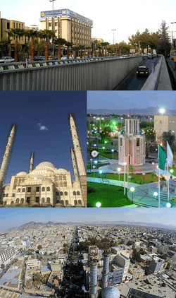
Zahedan is a centre for Sunni Muslims in Baluchistan. The Makki mosque and its madrasa play an important role in Baluchistan's society. Shaikh Abdolhamid Ismaeelzahi is the main and most influential religious and Sunni community leader in Iran that is heading Makki mosque and its institutions. Zahedan also has a Friday mosque for Shi'ite (Shia) and a Jame mosque, where many members of the community gather to worship on Fridays. A colorful bazaar, Rasouli Bazaar, can also be found in the city, where Baluchi and Pashtun traders intermingle. About 100 km (62 mi) south of Zahedan is an intermittently active volcano, Taftan, which rises abruptly 4,042 m (13,261 ft) from the surrounding plain.
Demographics
Although the surrounding area has many ancient sites, Zahedan itself developed mainly in the 20th century. Before being chosen as the provincial administrative center in the 1930s, Zahedan was a small village. Its population reached 17,500 by 1956 and increased more than fivefold to 93,000 by 1976. After 1980, large numbers of refugees fleeing the Soviet invasion of Afghanistan helped triple the population of Zahedan to more than 281,000 by 1986, a number which has since doubled again.
Etymology
Before the rise of Reza Shah Pahlavi in 1923, the city of Zahedan was known as Dozz-aap. That name was in turn derived from the Persian Dozd-aab, literally meaning "water thief". This is the name given to a sandy land formation that quickly swallows up any water that falls on it, be it rain or irrigation water.[7]
The name was changed to Zahedan by the Iranian Academy of Culture (the Farhangistan), set up during the reign of Reza Shah Pahlavi in the 1930s, which changed a myriad of toponyms in Iran. However, the name is not just a neologism: instead, it is taken from the medieval city of Zaidan, whose ruins stretch for miles on both banks of the lower Helmand river near its inland delta in Iranian Sistan (see, Henry Savage Landor, Across Coveted Lands, London 1902, chapter XXI). Although the imposing ruins of medieval Zaidan (destroyed by Tamerlane in the late 14th century) are tens of miles away from modern Zahedan, somehow it was seen fit to rename Dozd-aab after this prestigious historic city. A folk etymology maintains, however improbably, that the current name, Zahedan ("Sages," or "pious people" in Persian) was given to the city upon its visit by Reza Shah. It is believed that when Reza Shah visited the city he saw Sikhs in white robes living there and thus changed the name to Zahedan after the Sikhs who were considered Zahid (pious) by him.[8]
Sports
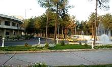
In April 2008 the 70 billion IRR (about 2.5 million USD) Zahedan Stadium was built with a seating capacity of 15,000 people. It was inaugurated on 18 April 2008 with a friendly football game between Honarmandan (Artists) versus a local team.
Economy
Zahedan is the main economic center of the region and home to many small- and medium-scale industries. Its main products include cotton textiles, woven and hand-knotted rugs, ceramics, processed foods, livestock feed, processed hides, milled rice, brick, reed mats and baskets.
Transport
Zahedan is served by Zahedan International Airport.
Highway 95 links Zahedan to Tehran and Mashhad in the north and the port of Bandar Chabahar on the Sea of Oman in the south, and Highway 84 to the Pakistani city of Quetta in the east and to Kerman in the west.
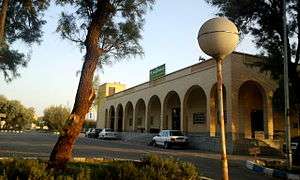
For many years, a broad gauge railway line has extended from Zahedan railway station to Quetta railway station in Pakistan along the Quetta–Taftan Railway Line. More recently, a standard gauge line was completed from Zahedan to Kerman in central Iran, linking Zahedan with the rest of the Iranian rail network.[9] This was the result of an 18 May 2007, MOU for rail cooperation that was signed by Pakistan and Iran under which the line was to be completed by December 2008.[10] The line was officially completed with an opening ceremony on 19 June 2009.[11] This makes Zahedan the location of the break of gauge between the Islamic Republic of Iran Railway's standard gauge tracks and Pakistan Railway's broad gauge tracks.
Chabahar–Zahedan railway
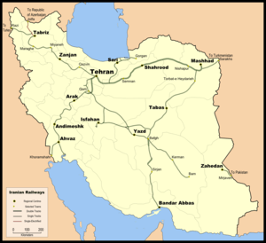
In May 2016, during Indian Prime Minister Narendra Modi's trip to Iran, agreement was signed to develop two terminals and five berths at Port of Chabahar and to build a new railway line between Chabahar and Zahedan, as part of North–South Transport Corridor, by Indian Railway's public sector unit Ircon International.[12]
The establishment of the port of Chabahar's connection to the country's railway plan is under study and consideration. With the completion of the Kerman–Zahedan railway and its connection to the port of Chabahar, this port will connect to the Trans-Iranian Railway.
In July 2016, India began shipping USD$150 million worth of rail tracks to Chabahar[13] to build USD$1.6 billion Chabahar–Zahedan railway by India's Ircon International, for which India pledged additional US$400 million and Iran has also allocated US$125 million in December 2016, thus taking the total allocation to US$575 million (out of US$1.6 billion needed) till the end of 2016.[14]
See also
- 2007 Zahedan bombings
- 2009 Zahedan bombings
- July 2010 Zahedan bombings
- 2019 Khash–Zahedan suicide bombing
Notes
References
- "Statistical Center of Iran > Home". www.amar.org.ir.
- Skrine, Clarmont (1962). World War In Iran. Constable & Company, Ltd. p. 68.
- Zahedan can be found at GEOnet Names Server, at this link, by opening the Advanced Search box, entering "-3088799" in the "Unique Feature Id" form, and clicking on "Search Database".
- "Zahedan Climate Normals 1961–1990". National Oceanic and Atmospheric Administration. Retrieved 19 December 2012.
- "دانشگاه آزاد اسلامی واحد زاهدان". www.iauzah.ac.ir.
- "خانه". www.zaums.ac.ir.
- "Sistan-Baluchestan; a natural paradise in Southeastern Iran". IRNA English. 13 August 2019.
- "Iran's connection to India's Sikhs". NDTV.com.
- Dr John Stubbs (1 January 2007). "Closing the gap from Bam to Zahedan". Railway Gazette International.
- "Intelligence". Railway Gazette International. 1 July 2007.
- "Zahedan | Railways of Afghanistan". www.andrewgrantham.co.uk.
- "Chabahar port: India to build 500 km rail line on southern coast of Iran as part of transit corridor to Afghanistan". DNA India. 23 May 2016.
- "India to export USD 150 mn rails for Chabahar port next month". 16 June 2016.
- "$125m for Chabahar-Zahedan Railroad". Financial Tribune. 24 December 2016.
External links

- Municipality of Zahedan
- Zahedan University of Medical Sciences
- Official Website of the Sunni Community of Iran, Sunnionline
