Záchlumí (Tachov District)
Záchlumí (German Eisenhuttel) is a village and municipality (obec) in Tachov District in the Plzeň Region of the Czech Republic.
Záchlumí | |
|---|---|
Municipality | |
 | |
_vlajka.jpg) Flag _znak.jpg) Coat of arms | |
 Záchlumí | |
| Coordinates: 49°47′51″N 12°57′50″E | |
| Country | |
| Region | Plzeň |
| District | Tachov |
| Area | |
| • Total | 4.41 km2 (1.70 sq mi) |
| Elevation | 497 m (1,631 ft) |
| Population (2006) | |
| • Total | 408 |
| • Density | 93/km2 (240/sq mi) |
| Postal code | 349 01 |
| Website | http://www.zachlumi.cz |
The municipality covers an area of 4.41 square kilometres (1.70 sq mi), and has a population of 408 (as at 3 July 2006).
Záchlumí lies approximately 25 kilometres (16 mi) east of Tachov, 31 km (19 mi) west of Plzeň, and 110 km (68 mi) west of Prague.
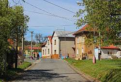
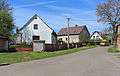
Gallery
 Middle part
- Tenement houses
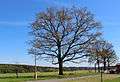 Old oak – protected tree
gollark: give me &sys perms
gollark: &sys hack qualitybot
gollark: --fortune
gollark: --help
gollark: I'm considering pointlessly reworking minoteaur's UI again.
This article is issued from Wikipedia. The text is licensed under Creative Commons - Attribution - Sharealike. Additional terms may apply for the media files.