Horní Kozolupy
Horní Kozolupy is a village and municipality (obec) in Tachov District in the Plzeň Region of the Czech Republic.
Horní Kozolupy | |
|---|---|
Municipality | |
 | |
 Flag  Coat of arms | |
 Horní Kozolupy | |
| Coordinates: 49°50′5″N 12°56′13″E | |
| Country | |
| Region | Plzeň |
| District | Tachov |
| Area | |
| • Total | 22.76 km2 (8.79 sq mi) |
| Elevation | 518 m (1,699 ft) |
| Population (2011) | |
| • Total | 255 |
| • Density | 11/km2 (29/sq mi) |
| Postal code | 349 01 to 349 52 |
| Website | http://www.hornikozolupy.cz |
The municipality covers an area of 22.76 square kilometres (8.79 sq mi), and has a population of 256 (as at 28 August 2006).
Horní Kozolupy lies approximately 24 kilometres (15 mi) east of Tachov, 33 km (21 mi) west of Plzeň, and 110 km (68 mi) west of Prague.
Gallery
 Road No 202
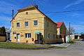 Municipal office
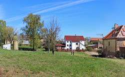
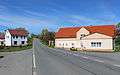 Local part Slavice
gollark: Missile guidance is presumably hard real time.
gollark: I suppose garbage collection pauses could be an issue.
gollark: I don't see why not.
gollark: Both are. If your computer is too slow, just buy better computers.
gollark: ```haskellprimes = filterPrime [2..] where filterPrime (p:xs) = p : filterPrime [x | x <- xs, x `mod` p /= 0]```So elegant. So concise. So incomprehensible.
References
| Wikimedia Commons has media related to Horní Kozolupy. |
| Wikimedia Commons has media related to Horní Kozolupy. |
This article is issued from Wikipedia. The text is licensed under Creative Commons - Attribution - Sharealike. Additional terms may apply for the media files.