Yap State
Yap State is one of the four states of the Federated States of Micronesia (FSM). The other states are Kosrae State, Pohnpei State, and Chuuk State.
Yap State | |
|---|---|
State | |
 Flag  Seal | |
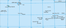 Map of Yap State | |
| Coordinates: 9°32′N 138°07′E | |
| Country | Federated States of Micronesia |
| Capital | Colonia |
| Government | |
| • Governor | Henry Falan |
| Area | |
| • Total | 119.54 km2 (46.15 sq mi) |
| Population (2010) | |
| • Total | 11,377 |
| • Density | 95/km2 (250/sq mi) |
| ISO 3166 code | FM-YAP |
| Website | www |
Colonia is the capital of Yap State, which administers both the Yap Main Islands and the island of Satawal, as well as fourteen atolls reaching to the east and south for some 800 km (500 mi), namely (municipalities in bold) Eauripik, Elato, Fais, Faraulep, Gaferut, Ifalik, Lamotrek, Ngulu, Olimarao, Piagailoe (West Fayu), Pikelot, Sorol, Ulithi, and Woleai. The outer islands and atolls reach to the east and south from the Yap Main Islands for some 800 km (500 mi (see map). Historically, a tributary system existed between the Neighboring Islands and the Yap Main Islands. This probably related to the need for goods from the high islands, including food, as well as wood for construction of seagoing vessels.
In 2000 the population of Colonia and ten other municipalities totalled 11,241. The state has a total land area of 102 km2 (39 sq mi).[1]
History
The state was once the Yap District of the Trust Territory of the Pacific Islands.
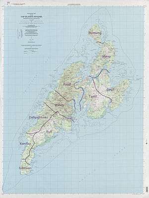
Geography
Yap State is the westernmost state of the FSM. To the east from near to far are Chuuk State, Pohnpei State, and Kosrae State.
Languages
Yap State has five official languages: English, Ulithian, Woleaian, Satawalese and Yapese.[2]
Demographics
The 2000 population was 7,391.
Politics
The current governor of Yap is Henry Falan.[4]
Yap has a group of chiefs known as the Council of Pilung and the Council of Tamol, who regulate cultural issues.[5]
Climate
| Climate data for Yap | |||||||||||||
|---|---|---|---|---|---|---|---|---|---|---|---|---|---|
| Month | Jan | Feb | Mar | Apr | May | Jun | Jul | Aug | Sep | Oct | Nov | Dec | Year |
| Record high °C (°F) | 33 (91) |
34 (93) |
34 (93) |
35 (95) |
35 (95) |
34 (94) |
34 (93) |
36 (96) |
34 (94) |
34 (94) |
34 (94) |
36 (96) |
36 (96) |
| Average high °C (°F) | 30.1 (86.2) |
30.2 (86.4) |
31.1 (88.0) |
31.2 (88.2) |
30.9 (87.6) |
30.7 (87.3) |
30.6 (87.1) |
30.8 (87.4) |
30.9 (87.6) |
30.9 (87.6) |
30.4 (86.7) |
30.7 (87.3) |
30.7 (87.3) |
| Daily mean °C (°F) | 26.8 (80.2) |
26.9 (80.4) |
27.5 (81.5) |
27.6 (81.7) |
27.3 (81.1) |
27.1 (80.8) |
27.1 (80.8) |
27.1 (80.8) |
27.2 (81.0) |
27.3 (81.1) |
27.1 (80.8) |
27.2 (81.0) |
27.2 (81.0) |
| Average low °C (°F) | 23.5 (74.3) |
23.5 (74.3) |
24.0 (75.2) |
24.1 (75.4) |
23.8 (74.8) |
23.6 (74.5) |
23.4 (74.1) |
23.4 (74.1) |
23.5 (74.3) |
23.7 (74.7) |
23.8 (74.8) |
23.7 (74.7) |
23.7 (74.7) |
| Record low °C (°F) | 19 (67) |
19 (66) |
19 (66) |
19 (67) |
18 (65) |
19 (66) |
18 (65) |
19 (66) |
19 (66) |
17 (63) |
18 (65) |
17 (63) |
17 (63) |
| Average precipitation mm (inches) | 186 (7.33) |
152 (5.98) |
151 (5.96) |
146 (5.76) |
230 (9.06) |
322 (12.69) |
369 (14.54) |
386 (15.20) |
343 (13.51) |
304 (11.97) |
230 (9.07) |
228 (8.99) |
3,050 (120.06) |
| Average precipitation days (≥ 1.0 mm) | 16.8 | 13.4 | 13.7 | 12.6 | 17.1 | 20.2 | 21.2 | 20.9 | 19.3 | 20.1 | 18.7 | 17.6 | 211.6 |
| Average relative humidity (%) | 82 | 81 | 80 | 79 | 81 | 83 | 84 | 84 | 84 | 84 | 83 | 83 | 82 |
| Mean monthly sunshine hours | 210.8 | 211.9 | 251.1 | 255.0 | 244.9 | 201.0 | 189.1 | 176.7 | 180.0 | 170.5 | 192.0 | 198.4 | 2,481.4 |
| Source 1: Weatherbase[6] | |||||||||||||
| Source 2: Hong Kong Observatory (sun, precipitation 1961–1990)[7] | |||||||||||||
Economy
Yap has a relatively small tourism industry, with the Yap Visitors Bureau reporting only 4,000 annual visitors from 2010 to 2017.[5] China's Exhibition & Travel Group has announced plans to develop a 4,000-unit resort on the island.[5]
Transportation
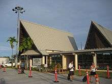
Yap International Airport receives service from United Airlines.
Education
Public schools:[8]
- Yap High School in Colonia
- Woleai High School in Woleai
- Outer Islands High School in Ulithi
Private schools:
- Yap Catholic High School in Lamer village, Rull[9]
See also
- Habele, a South Carolina–based charitable organization providing private economic educational assistance in Yap.
References
- "FSM Population". Fsmgov.org. Archived from the original on 2012-06-29. Retrieved 2012-06-15.
- "Yap, Federated States of Micronesia". Pacific Resources for Education and Learning. Retrieved 2006-10-24.
- Census 1987 with village population figures
- "Yap State Leaders 2019".
- Lin, Daniel (15 August 2017). "This Pacific Island Is Caught in a Global Power Struggle (And It's Not Guam)". 'National Geographic'.
- "Weatherbase: Historical Weather for Yap, Federated States of Micronesia". Weatherbase. Retrieved 13 December 2012.
- "Climatological Information for Yap, Pacific Islands, United States". Hong Kong Observatory. Retrieved 13 December 2012.
- "Higher Education in the Federated States of Micronesia." Embassy of the Federated States of Micronesia Washington DC. Retrieved on 23 February 2018.
- "ABOUT YCHS." Yap Catholic High School. Retrieved on 22 February 2018.
External links
| Wikimedia Commons has media related to Yap. |
- The Official Government Website for the Island of Yap
- Federated States of Micronesia – Yap, Chuuk, Pohnpei, Kosrae
- BBC
- Statistics on buildings, population; Source: Statistics Section, Office of Planning and Budget, Yap State
- United States of America and Japan – Treaty concerning the Yap Island and the other islands under mandate, situated in the Pacific North of the Equator and exchange of Notes relating thereto. Washington, 11 February 1922
- NOAA's National Weather Service – Yap, FSM
| History |
| ||
|---|---|---|---|
| Geography | |||
| Politics |
| ||
| Economy |
| ||
| Culture | |||
| |||