Wyoming Highway 411
Wyoming Highway 411 (WYO 411) is a 3.97-mile-long (6.39 km) Wyoming state road in central Uinta County. WYO 411 acts as a spur off WYO 410 to serve the community of Millburne that lies west of Mountain View.
| ||||
|---|---|---|---|---|
| Millburne Road | ||||
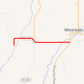
WYO 411 highlighted in red | ||||
| Route information | ||||
| Maintained by WYDOT | ||||
| Length | 3.97 mi[1] (6.39 km) | |||
| Major junctions | ||||
| West end | ||||
| East end | ||||
| Location | ||||
| Counties | Uinta | |||
| Highway system | ||||
State highways in Wyoming
| ||||

Route description
Wyoming Highway 411 begins its western end in Millburne at Uinta CR 260. From CR 260, Highway 411 travels east, crossing Blacks Fork as it leaves the small community of Millburne. As the roadway dips south and then east again, CR 219 is intersected that travels north to Fort Bridger. Continuing eastward, Smiths Fork is crossed just before the highway reaches its end at Wyoming Highway 410, just south of Mountain View, after approximately 4 miles.[2][3][4]
Major intersections
The entire route is in Uinta County.
| Location | mi | km | Destinations | Notes | |
|---|---|---|---|---|---|
| Millburne | 0.00 | 0.00 | Western terminus | ||
| | 3.97 | 6.39 | Eastern terminus | ||
| 1.000 mi = 1.609 km; 1.000 km = 0.621 mi | |||||
gollark: Perhaps turtles.
gollark: I wonder if there's some convoluted way to autokill it.
gollark: Such as?
gollark: It's in the lexica.
gollark: You can just fight the gaia guardian.
References
- Wyoming Department of Transportation Reference Marker Book - November 2004 (PDF) (Map). WYDOT. Archived from the original (PDF) on July 17, 2011. Retrieved 2011-10-19.
- Uinta County Roads
- Google (9 December 2011). "Overview Map of Wyoming Highway 411" (Map). Google Maps. Google. Retrieved 9 December 2011.
- Wyoming @ AARoads.com - Wyoming Routes 400-499
External links
This article is issued from Wikipedia. The text is licensed under Creative Commons - Attribution - Sharealike. Additional terms may apply for the media files.