Wyoming Highway 410
Wyoming Highway 410 (WYO 410) is a 13.36-mile-long (21.50 km) Wyoming state road in central Uinta County. Primarily a north-south route, WYO 410 travels east-west at its southern end.
| ||||
|---|---|---|---|---|
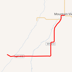
WYO 410 highlighted in red | ||||
| Route information | ||||
| Maintained by WYDOT | ||||
| Length | 13.36 mi[1] (21.50 km) | |||
| Existed | June 1971[2]–present | |||
| Major junctions | ||||
| South end | ||||
| North end | ||||
| Location | ||||
| Counties | Uinta | |||
| Highway system | ||||
State highways in Wyoming
| ||||

Route description
Wyoming Highway 410 begins its southern (western) end west of Robertson at Uinta CR 204. CR 204 continues west to Piedmont - a former small railroad and timber settlement which has become a ghost town. Highway 410 runs east, passing through the census-designated place of Robertson before reaching Uinta CR 283 where WYO 410 turns north. Highway 410 travels north, intersecting the eastern terminus of Wyoming Highway 411 before entering the town of Mountain View as West Street. Upon entering the town, WYO 410 curves east and becomes West 2nd Street.
Highway 410 reaches its end at Wyoming Highway 414.[3][4]
Major intersections
The entire route is in Uinta County. [5]
| Location[5] | mi | km | Destinations | Notes | |
|---|---|---|---|---|---|
| | 0.00 | 0.00 | Continuation beyond southern terminus | ||
| | 12.28 | 19.76 | Eastern terminus of WYO 411 | ||
| Mountain View | 13.36 | 21.50 | Northern terminus | ||
| 1.000 mi = 1.609 km; 1.000 km = 0.621 mi | |||||
References
- Wyoming Department of Transportation Reference Marker Book - November 2004 (PDF) (Map). WYDOT. Archived from the original (PDF) on July 17, 2011. Retrieved 2011-10-19.
- "New Highway Signs Appear". Casper Star-Tribune. June 25, 1971. p. 9. Retrieved December 18, 2019 – via Newspapers.com.

- Google (9 December 2011). "Overview Map of Wyoming Highway 410" (Map). Google Maps. Google. Retrieved 9 December 2011.
- Wyoming @ AARoads.com - Wyoming Routes 400-499
- Geography Division (2016). "Wyoming Governmental Unit Reference Map". United States Census Bureau. Retrieved January 24, 2017.