Wyoming Highway 113
Wyoming Highway 113 (WYO 113) is a 6.61-mile-long (10.64 km) east-west Wyoming State Road located in southwestern Crook County north of Moorcroft that provides travel to Pine Haven and Keyhole State Park that surrounds the Keyhole reservoir.
| ||||
|---|---|---|---|---|
| Old Sundance Road | ||||
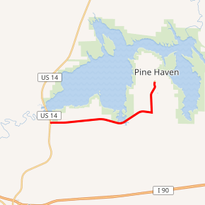
WYO 113 highlighted in red | ||||
| Route information | ||||
| Maintained by WYDOT | ||||
| Length | 6.61 mi[1] (10.64 km) | |||
| Major junctions | ||||
| West end | ||||
| East end | Pine Haven Road in Pine Haven | |||
| Location | ||||
| Counties | Crook | |||
| Highway system | ||||
State highways in Wyoming
| ||||

Route description
Wyoming Highway 113 travels from U.S. Route 14 5 miles (8.0 km) north of Moorcroft east, then north into Pine Haven near the Keyhole Reservoir. Mileposts along WYO 113 increase from west to east. Milepost 10.00 (0.00) is at US 14 and the highway ends at Milepost 16.61 (6.61)[1][2][3]
Major intersections
The entire route is in Crook County. [4]
| Location[4] | mi | km | Destinations | Notes | |
|---|---|---|---|---|---|
| | 0.00 | 0.00 | |||
| Pine Haven | 6.61 | 10.64 | Pine Haven Road | Continuation beyond eastern terminus | |
| 1.000 mi = 1.609 km; 1.000 km = 0.621 mi | |||||
gollark: oh apiobees.
gollark: ddg! "lyricly bad"
gollark: Yes. Purchase duck.
gollark: Seems reasonable, go buy one.
gollark: ddg! taobao rubber duck
References
- Wyoming Department of Transportation Reference Marker Book - November 2004 (PDF) (Map). WYDOT. Archived from the original (PDF) on July 17, 2011. Retrieved 2010-02-12.
- Wyoming @ AARoads.com - Wyoming Routes 100-199
- Google (3 September 2016). "Wyoming Highway 113" (Map). Google Maps. Google. Retrieved 3 September 2016.
- Geography Division (2016). "Wyoming Governmental Unit Reference Map". United States Census Bureau. Retrieved January 23, 2017.
This article is issued from Wikipedia. The text is licensed under Creative Commons - Attribution - Sharealike. Additional terms may apply for the media files.