Wroxton, Saskatchewan
Wroxton is an unincorporated community in Saskatchewan, located 41 km east of Yorkton, 42 km west of Roblin, Manitoba, and 40 km south of Kamsack at the intersection of Highway 8 and Highway 10.

Wroxton
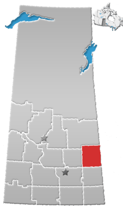
Location of Wroxton in Saskatchewan
It is the seat of the rural municipality Calder No. 241 in the Census Division 9.
History

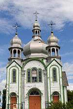
St. Elia Church

Church Plaque
Wroxton is home to the Ukrainian Orthodox Church of St. Elia, a cultural heritage site of Canada, number 3591 in the Canadian Register of Historic Places.[1]
A post office was opened in Wroxton in 1911.[2] It was named for Wroxton in Oxfordshire, England.[3]
Demographics
The RM of Calder No. 241 had a population of 322 people in the Canada Census of 2011, which was a decline of 23.9% since 2006.[4] The RM of Calder is governed by a Reeve and 5 councillors.[5]
gollark: How ideatic.
gollark: So a Turing machine can perform any computation that is possible to do [with a Turing machine].
gollark: Or do infinite computing in finite time, like some GTech™ stuff.
gollark: They CANNOT solve the halting problem.
gollark: WRONG.
References
- Canada's Historic Places - About
- National Archives, Archivia Net. "Post Offices and Postmasters". Retrieved 2014-04-22.
- Barry, Bill (September 2005). Geographic Names of Saskatchewan. Regina, Saskatchewan: People Places Publishing, Ltd. p. 465. ISBN 1-897010-19-2.
- "2011 Community Profiles". Statistics Canada. Government of Canada. Retrieved 2014-04-22.
- Government of Saskatchewan, MRD Home. "Municipal Directory System". Retrieved 2014-04-22.
This article is issued from Wikipedia. The text is licensed under Creative Commons - Attribution - Sharealike. Additional terms may apply for the media files.
