Worcester (CDP), Vermont
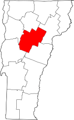
Worcester is a census-designated place (CDP) that comprises the main village in the town of Worcester, Washington County, Vermont, United States. The population of the CDP was 112 at the 2010 census.[2]
Worcester, Vermont | |
|---|---|
_highlighted.svg.png) Location in Washington County and the state of Vermont | |
| Coordinates: 44°22′23″N 72°32′58″W | |
| Country | United States |
| State | Vermont |
| County | Washington |
| Area | |
| • Total | 0.07 sq mi (0.17 km2) |
| • Land | 0.07 sq mi (0.17 km2) |
| • Water | 0 sq mi (0 km2) |
| Elevation | 775 ft (236 m) |
| Population (2010) | |
| • Total | 112 |
| • Density | 1,700/sq mi (660/km2) |
| Time zone | UTC-5 (Eastern (EST)) |
| • Summer (DST) | UTC-4 (EDT) |
| ZIP code | 05682 |
| Area code(s) | 802 |
| FIPS code | 50-86050[1] |
Geography
According to the United States Census Bureau, the Worcester CDP has a total area of 0.077 square miles (0.2 km2), all land.[3] The village is located along the North Branch of the Winooski River and Vermont Route 12, 9 miles (14 km) north of Montpelier, the state capital, and 18 miles (29 km) south of Morrisville.
gollark: You would just lose overclocking.
gollark: Which an H or B one could also do.
gollark: That would be some sort of B or H-series one.
gollark: No it's not.
gollark: No second referendum has been confirrmed.
References
- "U.S. Census website". United States Census Bureau. Retrieved 2008-01-31.
- "Profile of General Population and Housing Characteristics: 2010 Demographic Profile Data (DP-1): Worcester CDP, Vermont". United States Census Bureau. Retrieved September 20, 2012.
- "Geographic Identifiers: 2010 Demographic Profile Data (G001): Worcester CDP, Vermont". United States Census Bureau. Retrieved September 20, 2012.
This article is issued from Wikipedia. The text is licensed under Creative Commons - Attribution - Sharealike. Additional terms may apply for the media files.
