Woodsville Brook
Woodsville Brook is a tributary of the Stony Brook in Mercer County, New Jersey in the United States.
| Woodsville Brook | |
|---|---|
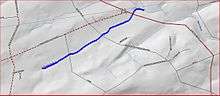 Map of Woodsville Brook | |
| Location | |
| Country | United States |
| Physical characteristics | |
| Source | |
| • coordinates | 40°22′8″N 74°50′27″W |
| Mouth | |
• coordinates | 40°23′2″N 74°48′55″W |
• elevation | 197 ft (60 m) |
| Basin features | |
| Progression | Stony Brook (Millstone River), Millstone River, Raritan River, Atlantic Ocean |
| River system | Raritan River system |
Course
Woodsville Brook starts at 40°22′8″N 74°50′27″W.[1] It flows northeast, crossing New Road and Marshalls Corner Woodsville Road. It then crosses Route 31 (Pennington Road) and Route 518 (Lambertville Hopewell Road) near to their intersection before joining the Stony Brook at 40°23′2″N 74°48′55″W.[1]
Sister tributaries
- Baldwins Creek
- Duck Pond Run
- Honey Branch
- Lewis Brook
- Peters Brook
- Stony Brook Branch
gollark: Yes, though I think I turned it off because it's stupid.
gollark: <@102038103463567360> What did you mean "tokenization approach"?
gollark: Fire*wolf*, not Fire*fox*.
gollark: Firewolf doesn't sandbox enough so you can make a website install potatOS.
gollark: Like Firewolf.
See also
References
- "GNIS Detail - Woodsville Brook". USGS. Retrieved 22 July 2010.
This article is issued from Wikipedia. The text is licensed under Creative Commons - Attribution - Sharealike. Additional terms may apply for the media files.