Baldwins Creek
Baldwins Creek is a tributary of the Stony Brook in Mercer County, New Jersey in the United States.
| Baldwins Creek | |
|---|---|
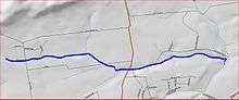 Map of Baldwins Creek | |
| Location | |
| Country | United States |
| Physical characteristics | |
| Source | |
| • location | 40°20′26″N 74°49′17″W |
| Mouth | |
• location | 40°20′21″N 74°46′41″W |
• elevation | 138 ft (42 m) |
| Basin features | |
| Progression | Stony Brook (Millstone River), Millstone River, Raritan River, Atlantic Ocean |
| River system | Raritan River system |
Course
Baldwins Creek starts at 40°20′26″N 74°49′17″W,[1] near Baldwin State Park. It flows east, flowing through Baldwin State Park and crossing Route 31 (Pennington Road). It flows through the Baldwin State Wildlife Management Area and joins Stony Brook at 40°20′21″N 74°46′41″W.[1]
Sister tributaries
gollark: But is it very reflective, almost metallic looking?
gollark: Another several days, another gold missed.
gollark: If NDs can be hatched in minutes then prizekins can be hatched in an hour or whatever.
gollark: Wait, release tonight?
gollark: But not in the hub!
See also
References
- "GNIS Detail - Baldwins Creek". USGS. Retrieved 22 July 2010.
External links
This article is issued from Wikipedia. The text is licensed under Creative Commons - Attribution - Sharealike. Additional terms may apply for the media files.