Wood Village, Oregon
Wood Village is a city in Multnomah County, Oregon, United States. The population was 3,878 at the 2010 census.[7] Despite the name, Wood Village is classified as a city.
Wood Village | |
|---|---|
| Wood Village, Oregon | |
 Seal | |
| Motto(s): The city that cares | |
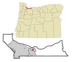
 Location in Oregon | |
| Coordinates: 45°32′6″N 122°25′7″W | |
| Country | United States |
| State | Oregon |
| County | Multnomah |
| Incorporated | 1951 |
| Government | |
| • Mayor | Timothy Clark[1] |
| Area | |
| • Total | 0.94 sq mi (2.44 km2) |
| • Land | 0.94 sq mi (2.44 km2) |
| • Water | 0.00 sq mi (0.00 km2) |
| Elevation | 90–330 ft (27.4 –100.6 m) |
| Population | |
| • Total | 3,878 |
| • Estimate (2019)[4] | 4,093 |
| • Density | 4,345.01/sq mi (1,677.01/km2) |
| Time zone | UTC-8 (Pacific) |
| • Summer (DST) | UTC-7 (Pacific) |
| ZIP code | 97060 |
| Area code(s) | 503 |
| FIPS code | 41-83950[5] |
| GNIS feature ID | 1136921[6] |
| Website | City of Wood Village |
History
Wood Village was built as a company town for the Reynolds Aluminum plant in Troutdale; the plant closed in 2000.[8] The city was also formerly home to a 90,000-square-foot (8,400 m2) Merix Corporation plant.[9]
Geography
According to the United States Census Bureau, the city has a total area of 0.94 square miles (2.43 km2), all of it land.[10]
Demographics
| Historical population | |||
|---|---|---|---|
| Census | Pop. | %± | |
| 1960 | 822 | — | |
| 1970 | 1,533 | 86.5% | |
| 1980 | 2,253 | 47.0% | |
| 1990 | 2,814 | 24.9% | |
| 2000 | 2,860 | 1.6% | |
| 2010 | 3,878 | 35.6% | |
| Est. 2019 | 4,093 | [4] | 5.5% |
| U.S. Decennial Census[11] 2013 Estimate[12] | |||
2010 census
At the 2010 census there were 3,878 people in 1,223 households, including 880 families, in the city. The population density was 4,125.5 inhabitants per square mile (1,592.9/km2). There were 1,289 housing units at an average density of 1,371.3 per square mile (529.5/km2). The racial makup of the city was 62.6% White, 2.0% African American, 2.3% Native American, 3.8% Asian, 0.2% Pacific Islander, 25.0% from other races, and 4.1% from two or more races. Hispanic or Latino of any race were 37.0%.[3]
Of the 1,223 households 46.4% had children under the age of 18 living with them, 48.4% were married couples living together, 16.3% had a female householder with no husband present, 7.3% had a male householder with no wife present, and 28.0% were non-families. 20.8% of households were one person and 5.3% were one person aged 65 or older. The average household size was 3.11 and the average family size was 3.59.
The median age was 30.7 years. 32.2% of residents were under the age of 18; 8.7% were between the ages of 18 and 24; 29.8% were from 25 to 44; 21.6% were from 45 to 64; and 7.5% were 65 or older. The gender makeup of the city was 50.9% male and 49.1% female.
2000 census
At the 2000 census there were 2,860 people in 1,014 households, including 701 families, in the city. The population density was 3,004.1 people per square mile (1,162.4/km2). There were 1,089 housing units at an average density of 1,143.9 per square mile (442.6/km2). The racial makup of the city was 81.68% White, 0.56% African American, 1.29% Native American, 1.71% Asian, 0.24% Pacific Islander, 9.86% from other races, and 4.65% from two or more races. Hispanic or Latino of any race were 15.21%.[5]
Of the 1,014 households 38.6% had children under the age of 18 living with them, 45.9% were married couples living together, 16.8% had a female householder with no husband present, and 30.8% were non-families. 23.9% of households were one person and 6.8% were one person aged 65 or older. The average household size was 2.76 and the average family size was 3.22.
The age distribution was 28.6% under the age of 18, 10.2% from 18 to 24, 32.8% from 25 to 44, 19.7% from 45 to 64, and 8.6% 65 or older. The median age was 31 years. For every 100 females, there were 102.7 males. For every 100 females age 18 and over, there were 97.2 males.
The median household income was $43,384 and the median family income was $48,167. Males had a median income of $31,577 versus $25,500 for females. The per capita income for the city was $17,833. About 6.9% of families and 8.3% of the population were below the poverty line, including 7.9% of those under age 18 and 2.9% of those age 65 or over.
Transportation
TriMet serves the city with bus service and connections to light rail.
References
- "Mayor & Council". City of Wood Village. Retrieved May 3, 2017.
- "2019 U.S. Gazetteer Files". United States Census Bureau. Retrieved July 28, 2020.
- "U.S. Census website". United States Census Bureau. Retrieved 2012-12-21.
- "Population and Housing Unit Estimates". United States Census Bureau. May 24, 2020. Retrieved May 27, 2020.
- "U.S. Census website". United States Census Bureau. Retrieved 2008-01-31.
- "US Board on Geographic Names". United States Geological Survey. 2007-10-25. Retrieved 2008-01-31.
- "2010 Census Redistricting Data (Public Law 94-171) Summary File". American FactFinder. United States Census Bureau. Retrieved 11 August 2011.
- Mayer, James (April 19, 2012). "Aluminum Plant Gone, but Memories Remain". The Oregonian. Retrieved June 10, 2014.
- Merix Corporation 2006 Annual Report
- "US Gazetteer files 2010". United States Census Bureau. Retrieved 2012-12-21.
- United States Census Bureau. "Census of Population and Housing". Retrieved September 26, 2014.
- "Population Estimates". United States Census Bureau. Retrieved 2014-09-26.
