Withcott
Withcott is a rural town and locality in the Lockyer Valley Region, Queensland, Australia.[2][3] In the 2016 census, Withcott had a population of 1844 people.[1]
| Withcott Queensland | |||||||||||||||
|---|---|---|---|---|---|---|---|---|---|---|---|---|---|---|---|
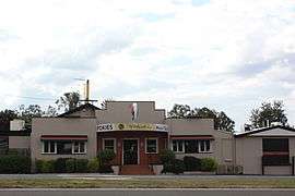
 Withcott Hotel | |||||||||||||||
 Withcott | |||||||||||||||
| Coordinates | 27.5536°S 152.0238°E | ||||||||||||||
| Population | 1,844 (2016 census)[1] | ||||||||||||||
| • Density | 60.07/km2 (155.57/sq mi) | ||||||||||||||
| Postcode(s) | 4352 | ||||||||||||||
| Area | 30.7 km2 (11.9 sq mi) | ||||||||||||||
| Time zone | AEST (UTC+10:00) | ||||||||||||||
| Location | |||||||||||||||
| LGA(s) | Lockyer Valley Region | ||||||||||||||
| State electorate(s) | Lockyer | ||||||||||||||
| Federal Division(s) | Wright | ||||||||||||||
| |||||||||||||||
Geography
Withcott is in the Lockyer Valley. The town is located on the Warrego Highway, 116 kilometres (72 mi) west of the state capital, Brisbane and 10 kilometres (6.2 mi) east of the regional centre of Toowoomba.
History
Withcott State School opened in September 1912. It closed on 30 Apr 1971. It reopened on 31 January 1984 in a new building.[4]
At the 2006 census, Withcott had a population of 1,000.[5]
During the 2010–2011 Queensland floods, Withcott suffered extensive damage when a flash flood hit the town on 10 January 2011.[6]
Education
Withcott State School is a government primary (Prep-6) school for boys and girls at 26 Biggs Road (27.5594°S 152.0237°E).[7][8] In 2017, the school had an enrolment of 198 students with 17 teachers (13 full-time equivalent) and 17 non-teaching staff (9 full-time equivalent).[9]
Community groups
The Upper Lockyer Withcott branch of the Queensland Country Women's Association meets at 4 Biggs Road, adjoining to the Warrego Highway. This was demolished in late 2018 and has since been turned into a public day use facility, containing a bathroom and undercover dining & seating area.[10]
References
- Australian Bureau of Statistics (27 June 2017). "Withcott (SSC)". 2016 Census QuickStats. Retrieved 20 October 2018.

- "Withcott - town in Lockyer Valley Region (entry 37773)". Queensland Place Names. Queensland Government. Retrieved 16 November 2019.
- "Withcott - locality in Lockyer Valley Region (entry 45019)". Queensland Place Names. Queensland Government. Retrieved 16 November 2019.
- Queensland Family History Society (2010), Queensland schools past and present (Version 1.01 ed.), Queensland Family History Society, ISBN 978-1-921171-26-0
- Australian Bureau of Statistics (25 October 2007). "Withcott (L) (Urban Centre/Locality)". 2006 Census QuickStats. Retrieved 11 January 2011.
- Johnson, Callum (10 January 2010). "Withcott evacuated". Toowoomba Chronicle. Retrieved 11 January 2011.
- "State and non-state school details". Queensland Government. 9 July 2018. Archived from the original on 21 November 2018. Retrieved 21 November 2018.
- "Withcott State School". Retrieved 21 November 2018.
- "ACARA School Profile 2017". Archived from the original on 22 November 2018. Retrieved 22 November 2018.
- "Branch Locations". Queensland Country Women's Association. Retrieved 26 December 2018.
External links
| Wikimedia Commons has media related to Withcott, Queensland. |
- "Withcott". Queensland Places. Centre for the Government of Queensland, University of Queensland.