Plainland
Plainland is a rural locality in the Lockyer Valley Region, Queensland, Australia.[2] In the 2016 census, Plainland had a population of 1,596 people.[1]
| Plainland Queensland | |||||||||||||||
|---|---|---|---|---|---|---|---|---|---|---|---|---|---|---|---|
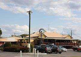 Porter's Plainland Hotel, opened in 1908 | |||||||||||||||
 Plainland | |||||||||||||||
| Coordinates | 27.5816°S 152.4163°E | ||||||||||||||
| Population | 1,596 (2016 census)[1] | ||||||||||||||
| • Density | 71.57/km2 (185.4/sq mi) | ||||||||||||||
| Postcode(s) | 4341 | ||||||||||||||
| Area | 22.3 km2 (8.6 sq mi) | ||||||||||||||
| Time zone | AEST (UTC+10:00) | ||||||||||||||
| Location | |||||||||||||||
| LGA(s) | Lockyer Valley Region | ||||||||||||||
| County | Churchill | ||||||||||||||
| Parish | Laidley | ||||||||||||||
| State electorate(s) | Lockyer | ||||||||||||||
| Federal Division(s) | Blair | ||||||||||||||
| |||||||||||||||
Geography
Plainland is in the Lockyer Valley, located 75 kilometres (47 mi) west of Brisbane, the state capital, along the Warrego Highway.
History
Plainland was settled by a dozen German families in 1878. The families were mostly from West Prussia. The community constructed a Lutheran church in 1884 which was replaced in 1897. About 60 families, mainly of German origin were living in the area in 1911—serviced by three blacksmiths, the Plainland Hotel, a state school and a general store.[3]
Plainland State School opened circa 1886. It closed on 1966.[4]
Plainland Post Office opened by 1899 (a receiving office had been open from 1887) and closed in 1966.[5]
The area experienced a general decline in population throughout the mid-20th century until the 1990s when significant development began.
Faith Lutheran College opened on 1999.[4]
At the 2011 census Plainland had a population of 1,672 people.[6]
In the 2016 census, Plainland had a population of 1,596 people.[1]
In the late 2010s. the area experienced a boom in development with projects such as Plainland Crossing and Meadows at Plainland, expanding the availability of rural residential properties.[7][8]
Development
A variety of new civic services such as schools, services, and large-chain shopping options have also been developed or announced.[9] The town has also been identified as a growth hub, and the preferred location for a new regional hospital to provide emergency and maternity services to the Lockyer Valley.[10]
Events
A farmers' market is held adjacent to the hotel on Sundays.[3]
Education
Faith Lutheran College is a private secondary (7-12) school for boys and girls at 5 Faith Avenue (27.5680°S 152.4161°E), operated by Lutheran Education Queensland.[11][12] In 2016, the school had an enrolment of 719 students with 56 teachers (53.95 full-time equivalent) and 63 non-teaching staff (48.95 full-time equivalent).[13] In 2017, the school had an enrolment of 711 students with 59 teachers (57 full-time equivalent) and 63 non-teaching staff (43 full-time equivalent).[14]
Plainland Kindergarten & Child Care provides care to young children.
A new Catholic secondary school is scheduled to open at 54-56 Otto Road and 29-33 Gehrke Road offering Year 7 enrolments in 2021 (named Sophia College).[15][16]
References
- Australian Bureau of Statistics (27 June 2017). "Plainland (SSC)". 2016 Census QuickStats. Retrieved 20 October 2018.

- "Plainland - locality in Lockyer Valley Region (entry 44984)". Queensland Place Names. Queensland Government. Retrieved 30 November 2019.
- "Plainland". Queensland Places. Centre for the Government of Queensland. Archived from the original on 2 November 2012. Retrieved 18 June 2012.
- Queensland Family History Society (2010), Queensland schools past and present (Version 1.01 ed.), Queensland Family History Society, ISBN 978-1-921171-26-0
- Premier Postal History. "Post Office List". Premier Postal Auctions. Retrieved 10 May 2014.
- Australian Bureau of Statistics (31 October 2012). "Plainland (SSC)". 2011 Census QuickStats. Retrieved 22 June 2012.
- "Plainland Crossing". Archived from the original on 24 July 2019. Retrieved 4 December 2019.
- "Meadows at Plainland | Space, Privacy and Convenience". QM Properties. Archived from the original on 26 March 2019. Retrieved 4 December 2019.
- "Latest News and Information". Plainland Crossing. Archived from the original on 4 March 2019.
- "Lockyer Valley Economic and Development Plan 2018-2023" (PDF). Lockyer Valley Regional Council. pp. 10, 20, 34, 36. Archived (PDF) from the original on 8 April 2019.
- "State and non-state school details". Queensland Government. 9 July 2018. Archived from the original on 21 November 2018. Retrieved 21 November 2018.
- "Faith Lutheran College". Archived from the original on 1 December 2018. Retrieved 21 November 2018.
- "Annual Report 2016" (PDF). Faith Lutheran College Plainland. Archived (PDF) from the original on 13 September 2017. Retrieved 14 September 2017.
- "ACARA School Profile 2017". Archived from the original on 22 November 2018. Retrieved 22 November 2018.
- "2019 Catholic Secondary College Opening at Plainland 2021". www.olgcgatton.qld.edu.au. Archived from the original on 10 March 2019. Retrieved 29 November 2019.
- "New Schools". Brisbane Catholic Education. Archived from the original on 4 December 2019. Retrieved 4 December 2019.
External links
| Wikimedia Commons has media related to Plainland, Queensland. |
- "Plainland". Queensland Places. Centre for the Government of Queensland, University of Queensland.