Wingfield Township, Geary County, Kansas
Wingfield Township is a township in Geary County, Kansas, USA. As of the 2000 census, its population was 139.
Wingfield Township | |
|---|---|
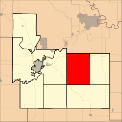 Location in Geary County | |
| Coordinates: 39°00′55″N 096°39′01″W | |
| Country | United States |
| State | Kansas |
| County | Geary |
| Area | |
| • Total | 47.61 sq mi (123.32 km2) |
| • Land | 47.61 sq mi (123.32 km2) |
| • Water | 0 sq mi (0 km2) 0% |
| Elevation | 1,368 ft (417 m) |
| Population (2000) | |
| • Total | 139 |
| • Density | 2.9/sq mi (1.1/km2) |
| GNIS feature ID | 0476722 |
Geography
Wingfield Township covers an area of 47.61 square miles (123.3 km2) and contains no incorporated settlements. According to the USGS, it contains two cemeteries: Humboldt and Saint Joseph's.
The streams of East McDowell Creek, MacArthur Branch, Pressee Branch, Swede Creek, Thierer Branch and West McDowell Creek run through this township.
gollark: By the way, you should dial +441234815763 immediately.
gollark: What interesting assumptions.
gollark: What if palaiologos literally mitogen-activated protein kinase kinase kinase kinase 4?
gollark: Just compute faster.
gollark: This is just Solomonoff induction but worse.
Further reading
External links
Municipalities and communities of Geary County, Kansas, United States | ||
|---|---|---|
| Cities | 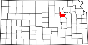 Map of Kansas highlighting Geary County | |
| CDP | ||
| Unincorporated communities | ||
| Ghost towns | ||
| Townships | ||
| Footnotes | ‡This populated place also has portions in an adjacent county or counties | |
This article is issued from Wikipedia. The text is licensed under Creative Commons - Attribution - Sharealike. Additional terms may apply for the media files.