Jefferson Township, Geary County, Kansas
Jefferson Township is a township in Geary County, Kansas, USA. As of the 2000 census, its population was 1,651.
Jefferson Township | |
|---|---|
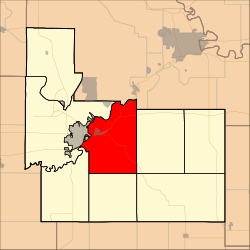 Location in Geary County | |
| Coordinates: 39°00′02″N 096°45′41″W | |
| Country | United States |
| State | Kansas |
| County | Geary |
| Area | |
| • Total | 48.44 sq mi (125.46 km2) |
| • Land | 47.69 sq mi (123.51 km2) |
| • Water | 0.75 sq mi (1.95 km2) 1.55% |
| Elevation | 1,289 ft (393 m) |
| Population (2000) | |
| • Total | 1,651 |
| • Density | 34.6/sq mi (13.4/km2) |
| GNIS feature ID | 0476710 |
History
Jefferson Township was established in 1878. It was named for Thomas Jefferson.[1]
Geography
Jefferson Township covers an area of 48.44 square miles (125.5 km2) and contains one incorporated settlement, Grandview Plaza. According to the USGS, it contains two cemeteries: Fairview and Rosey.
Whiskey Lake is within this township. The streams of Clarks Creek, Davis Creek, Dry Creek, Franks Creek and Humboldt Creek run through this township.
Transportation
Jefferson Township contains one airport or landing strip, Marshall Airfield.
gollark: You don't have push notifications?
gollark: <@231856503756161025> Did you receive my electronic mail?
gollark: Except optionally.
gollark: But not RPN.
gollark: Maybe I should make RPNCalcV6.
References
- "Geary County History (archived)". Geary County Historical Society. Archived from the original on October 12, 2013. Retrieved 10 June 2014.
Further reading
External links
Municipalities and communities of Geary County, Kansas, United States | ||
|---|---|---|
| Cities | 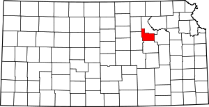 Map of Kansas highlighting Geary County | |
| CDP | ||
| Unincorporated communities | ||
| Ghost towns | ||
| Townships | ||
| Footnotes | ‡This populated place also has portions in an adjacent county or counties | |
This article is issued from Wikipedia. The text is licensed under Creative Commons - Attribution - Sharealike. Additional terms may apply for the media files.