Wiesenau
Wiesenau is a municipality in the Oder-Spree district, in Brandenburg, Germany.[2]
Wiesenau | |
|---|---|
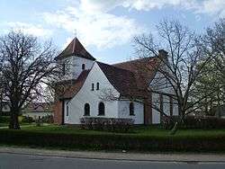 Village church | |
 Coat of arms | |
Location of Wiesenau within Oder-Spree district 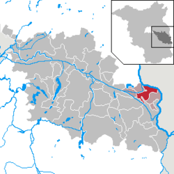 | |
 Wiesenau  Wiesenau | |
| Coordinates: 52°13′59″N 14°35′59″E | |
| Country | Germany |
| State | Brandenburg |
| District | Oder-Spree |
| Municipal assoc. | Brieskow-Finkenheerd |
| Government | |
| • Mayor | Rainer Bublak (SPD) |
| Area | |
| • Total | 29.59 km2 (11.42 sq mi) |
| Elevation | 39 m (128 ft) |
| Population (2018-12-31)[1] | |
| • Total | 1,273 |
| • Density | 43/km2 (110/sq mi) |
| Time zone | CET/CEST (UTC+1/+2) |
| Postal codes | 15295 |
| Dialling codes | 033609 |
| Vehicle registration | LOS |
| Website | http://www.brieskow-finkenheerd.de/ |
Demography
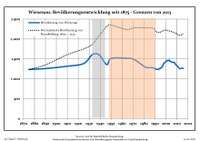 Development of population since 1875 within the current Boundaries (Blue Line: Population; Dotted Line: Comparison to Population development in Brandenburg state; Grey Background: Time of Nazi Germany; Red Background: Time of communist East Germany)
|
|
gollark: It supports that.
gollark: I mean, I could write nim on the frontend too I guess?
gollark: I'll probably do it if I can work out how to append after things in J§.
gollark: It actually would simplify the CSS somewhat, too.
gollark: I was thinking a search sidebar could be good, *but* it would possibly be too narrow.
References
- "Bevölkerung im Land Brandenburg nach amtsfreien Gemeinden, Ämtern und Gemeinden 31. Dezember 2018". Amt für Statistik Berlin-Brandenburg (in German). July 2019.
- Mapa Polski 1:500 000 Wojskowy Instytut Geograficzny Sztabu Generalnego W.P., Warszawa 1947
- Detailed data sources are to be found in the Wikimedia Commons.Population Projection Brandenburg at Wikimedia Commons
Towns and municipalities in Oder-Spree | ||
|---|---|---|
| Coat of Arms of Oder-Spree district | |
| Wikimedia Commons has media related to Wiesenau. |
This article is issued from Wikipedia. The text is licensed under Creative Commons - Attribution - Sharealike. Additional terms may apply for the media files.