Schlaubetal
Schlaubetal is a municipality in the Oder-Spree district, in Brandenburg, Germany.
Schlaubetal | |
|---|---|
 Coat of arms | |
Location of Schlaubetal within Oder-Spree district 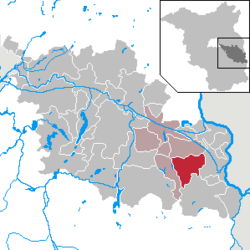 | |
 Schlaubetal  Schlaubetal | |
| Coordinates: 52°07′00″N 14°30′00″E | |
| Country | Germany |
| State | Brandenburg |
| District | Oder-Spree |
| Municipal assoc. | Schlaubetal |
| Subdivisions | 3 districts |
| Government | |
| • Mayor | Siegmund Vogelsänger (SVK 1990 e.V.) |
| Area | |
| • Total | 52.34 km2 (20.21 sq mi) |
| Elevation | 118 m (387 ft) |
| Population (2018-12-31)[1] | |
| • Total | 1,840 |
| • Density | 35/km2 (91/sq mi) |
| Time zone | CET/CEST (UTC+1/+2) |
| Postal codes | 15890 |
| Dialling codes | 033654 |
| Vehicle registration | LOS |
Demography
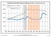 Development of population since 1875 within the current Boundaries (Blue Line: Population; Dotted Line: Comparison to Population development in Brandenburg state; Grey Background: Time of Nazi Germany; Red Background: Time of communist East Germany)
|
|
gollark: But you can also write a program to just directly run from a URL, like that one.
gollark: Yes.
gollark: If you want to run stuff downloaded from the interweb in a script then:```lualocal h = http.get "whatever URL"local x = h.readAll()h.close()local fn, err = load(x, "@thing")if not fn then error(err) endfn(...)```
gollark: You can actually just use `wget run [URL]` or something in the command prompt.
gollark: If you want to save it to a file then```lualocal h = http.get "whatever URL"local f = fs.open("whatever file", "w")f.write(h.readAll())h.close()```
References
- "Bevölkerung im Land Brandenburg nach amtsfreien Gemeinden, Ämtern und Gemeinden 31. Dezember 2018". Amt für Statistik Berlin-Brandenburg (in German). July 2019.
- Detailed data sources are to be found in the Wikimedia Commons.Population Projection Brandenburg at Wikimedia Commons
Towns and municipalities in Oder-Spree | ||
|---|---|---|
| Coat of Arms of Oder-Spree district | |
This article is issued from Wikipedia. The text is licensed under Creative Commons - Attribution - Sharealike. Additional terms may apply for the media files.