Westerveld
Westerveld (![]()
Westerveld | |
|---|---|
 Town of Dwingeloo | |
 Flag Coat of arms | |
.svg.png) Location in Drenthe | |
| Coordinates: 52°52′N 6°19′E | |
| Country | Netherlands |
| Province | Drenthe |
| Established | 1 January 1998[1] |
| Government | |
| • Body | Municipal council |
| • Mayor | Rikus Jager (CDA) |
| Area | |
| • Total | 282.74 km2 (109.17 sq mi) |
| • Land | 278.81 km2 (107.65 sq mi) |
| • Water | 3.93 km2 (1.52 sq mi) |
| Elevation | 8 m (26 ft) |
| Population (January 2019)[5] | |
| • Total | 19,348 |
| • Density | 69/km2 (180/sq mi) |
| Time zone | UTC+1 (CET) |
| • Summer (DST) | UTC+2 (CEST) |
| Postcode | Parts of 7000 and 8000 range |
| Area code | 0521, 0561 |
| Website | gemeentewesterveld |
The municipality Westerveld was established in 1998 out of the municipalities of Diever, Dwingeloo, Havelte, and Vledder. Westerveld is crossed by a channel, the Drentsche Hoofdvaart. There are also two National Parks situated in the municipality, the Drents-Friese Wold and Dwingelerveld.
Population centres
Dwingeloo is a town halfway between Meppel and Assen. The radio telescope of the Dwingeloo Radio Observatory is located on the edge of the Dwingeloo Heath, 3 km (2 mi) south of the village.
Topography
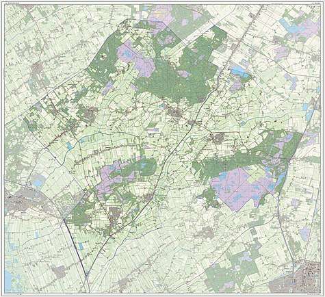
Dutch Topographic map of the municipality of Westerveld, 2013.
Notable people
.jpg)
Hans Hugenholtz, 1961
- Sicco Mansholt (1908 in Ulrum – 1995) politician, 4th President of the European Commission 1972-1973
- John Hugenholtz (1914 in Vledder – 1995) designer of race tracks and cars
- Jan Pol (born 1942 in Wateren) veterinarian, & TV Personality
- Jan Mulder (born 1943 in Diever) politician and Member of the European Parliament
- Klaske Hiemstra (born 1954 in Vledder) a West Frisian-language writer
- Maarten Treurniet (born 1959) film director, brought up in Dwingeloo [6]
- Merlijn Twaalfhoven (born 1976 in Wapserveen) Dutch composer
Sport
- Gerrit Postma (1894 in Vledderveen – 1969) discus thrower, competed at the 1928 Summer Olympics
- Tollien Schuurman (1913 in Zorgvlied – 1994) sprint runner, competed at the 1932 Summer Olympics
- Riëtte Fledderus (born 1977) retired volleyball player, competed at the 1996 Summer Olympics
Gallery
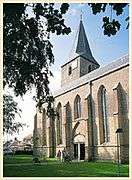 Hervormde Karke Dever
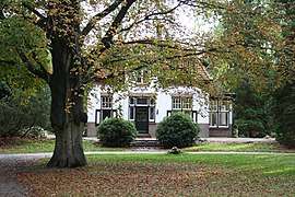 Dwingeloo - De Bork - Westeinde
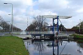 Drentsche Hoofdvaart, Uffelterbrug
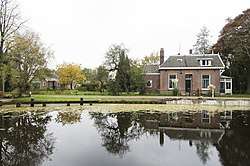
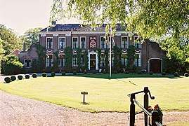 De havezate Oldengaerde te Dwingeloo
gollark: Not small stuff like that: I'm trying to decide which language/framework to use.Also, promises are generally preferred.
gollark: Peril of starting a programming project #1004: spending ages trying to decide what to use.
gollark: You wanted people to suffer through Dropbox?
gollark: ...
gollark: Then why didn't you use it?
References
- "Gemeentelijke indeling op 1 januari 1998" [Municipal divisions on 1 January 1998]. cbs.nl (in Dutch). CBS. Retrieved 11 October 2013.
- "Samenstelling van het college van burgemeester en wethouders" [Members of the board of mayor and aldermen] (in Dutch). Gemeente Westerveld. Retrieved 12 October 2013.
- "Kerncijfers wijken en buurten" [Key figures for neighbourhoods]. CBS Statline (in Dutch). CBS. 2 July 2013. Retrieved 12 March 2014.
- "Postcodetool for 7981EL". Actueel Hoogtebestand Nederland (in Dutch). Het Waterschapshuis. Retrieved 12 October 2013.
- "Bevolkingsontwikkeling; regio per maand" [Population growth; regions per month]. CBS Statline (in Dutch). CBS. 1 January 2019. Retrieved 1 January 2019.
- IMDb Database retrieved 7 June 2019
External links
Places adjacent to Westerveld | ||||||||||
|---|---|---|---|---|---|---|---|---|---|---|
| ||||||||||
Municipalities of Drenthe | ||
|---|---|---|
 | ||
| ||
This article is issued from Wikipedia. The text is licensed under Creative Commons - Attribution - Sharealike. Additional terms may apply for the media files.