Western Beskids
The Western Beskids (Czech: Západní Beskydy; Slovak: Západné Beskydy; Polish: Beskidy Zachodnie; German: Westbeskiden) are a set of mountain ranges spanning the Czech Republic, Slovakia, and Poland. Geologically the Western Beskids are part of the Outer Western Carpathians.
| Western Beskids | |
|---|---|
_-_the_river.jpg) Čeladenka River in the Moravian-Silesian Beskids | |
| Highest point | |
| Peak | Lysá hora |
| Elevation | 1,323 m (4,341 ft) |
| Coordinates | 49°32′45″N 18°26′51″E |
| Naming | |
| Native name | Západní Beskydy (cs) Beskidy Zachodnie (pl) |
| Geography | |
| Countries | Czech Republic, Slovakia and Poland |
| Regions | Moravia, Czech Silesia and Lesser Poland |
| Parent range | Outer Western Carpathians |
| Borders on | List
|
Traditionally the Western Beskids were considered part of the Beskids, a term that differs according to historical and linguistic heritage.
Subdivision
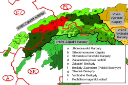
Western section of Western Beskids, marked in red and labeled with E
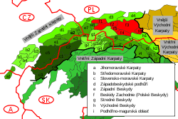
Northern section of Western Beskids, marked in red and labeled with F
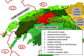
Central section of the Western Beskids, marked in red and labeled with G
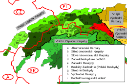
Eastern section of the Western Beskids, marked in red and labeled with H
The Western Beskids consist of the following mountain ranges:
- Western section of the Western Beskids:
- Hostýn-Vsetín Mountains (Czech: Hostýnsko-vsetínská hornatina) → e1
- Moravian-Silesian Beskids (Czech: Moravskoslezské Beskydy, Slovak: Moravsko-sliezske Beskydy) → e2
- Turzovka Highlands (Slovak: Turzovská vrchovina) → e3
- Jablunkov Furrow (Czech: Jablunkovská brázda) → e4
- Rožnov Furrow (Czech: Rožnovská brázda) → e5
- Jablunkov Intermontane (Slovak: Jablunkovské medzihorie, Czech: Jablunkovské mezihoří) → e6
- Silesian Beskids (Polish: Beskid Śląski, Czech: Slezské Beskydy) → e7
- Żywiec Basin (Polish: Kotlina Żywiecka) → e8
- Northern section of the Western Beskids:
- Little Beskids (Polish: Beskid Mały) → f1
- Maków Beskids (Polish: Beskid Makowski) → f2
- Island Beskids (Polish: Beskid Wyspowy) → f3
- Gorce Mountains (Polish: Gorce) → f4
- Rabka Basin (Polish: Kotlina Rabczańska) → f5
- Sącz Basin (Polish: Kotlina Sądecka) → f6
- Central section of the Western Beskids:
- Orava Beskids (SK: Oravské Beskydy) + Żywiec Beskids (PL: Beskid Żywiecki) (the older SK equivalent of Beskid Zywiecki is "Slovenské Beskydy" - Slovak Beskids or "Kysucko-oravské Beskydy" - Kysuce-Orava Beskids) → g1
- Kysuce Beskids (SK: Kysucké Beskydy) +Żywiec Beskids (PL: Beskid Żywiecki) (the older SK equivalent of Beskid Zywiecki is "Slovenské Beskydy" or "Kysucko-oravské Beskydy") → g2
- Orava Magura (SK: Oravská Magura) → g3
- Orava Highlands (SK: Oravská vrchovina) → g4
- Sub-Beskidian Furrow (SK: Podbeskydská brázda) → g5
- Sub-Beskidian Highlands (SK: Podbeskydská vrchovina) → g6
gollark: * 8009.044
gollark: Well, then actually explicitly write that in.
gollark: If a rule is going to be enforced randomly, it shouldn't be there.
gollark: Then delete it.
gollark: <@!356107472269869058> Databases good, lack of databases less good.
See also
- Western Beskidian Foothills
- Podhale-Magura Area
- Outer Western Carpathians
- Divisions of the Carpathians
Maps
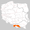 Parts of Western Beskids, within the borders of Poland
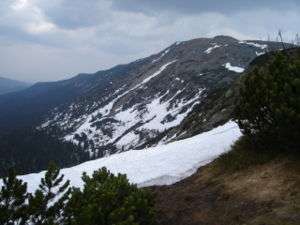 Babia Góra, the highest peak of the Orava Beskids, within central section of Western Beskids
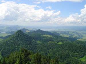 Pieniny Mountains, the eastern ranges of Western Beskids
Sources
- Földvary, Gábor Z. (1988). Geology of the Carpathian Region. Singapore: World Scientific Publishing Company.CS1 maint: ref=harv (link)
- Kondracki, Jerzy (1977). Regiony fizycznogeograficzne Polski. Warszawa: Wydawa Uniwersytetu Warszawskiego.CS1 maint: ref=harv (link)
- Kondracki, Jerzy (1989). Problemy standaryzacji nazw geograficznych. Warszawa: Instytut Geografii i Przestrzennego Zagospodarowania PWN.CS1 maint: ref=harv (link)
- Kondracki, Jerzy (2000) [1998]. Geografia regionalna Polski (2. ed.). Warszawa: Wydawnictwo Naukowe PWN.CS1 maint: ref=harv (link)
External links
| Wikimedia Commons has media related to Western Beskids. |
This article is issued from Wikipedia. The text is licensed under Creative Commons - Attribution - Sharealike. Additional terms may apply for the media files.
