Transylvanian Plateau
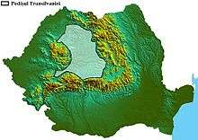
The Transylvanian Plateau (Romanian: Podişul Transilvaniei, Hungarian: Erdélyi-medence) is a plateau in central Romania.

The plateau lies within and takes its name from the historical region of Transylvania, and is almost entirely surrounded by the Eastern, Southern and Romanian Western branches of the Carpathian Mountains. The area includes the Transylvanian Plain.
It is improperly called a plateau, for it does not possess extensive plains, but is formed of a network of valleys of various size, ravines and canyons, united together by numerous small mountain ranges, which attain a height of 150-250 m (500-800 ft) above the altitude of the valley.[1]
The plateau has a continental climate. Temperature varies a great deal in the course of a year, with warm summers contrasted by very cold winters. Vast forests cover parts of the plateau and the mountains. The mean elevation is 300-500 m (1,000-1,600 ft).
The Transylvanian plateau is divided into three areas:
- Someș Plateau (Podișul Someșan or Podișul Someșelor; the northern part)
- Transylvanian Plain (Câmpia Transilvaniei; the central part)
- Târnava Plateau (Podișul Târnavelor; the southern part)
The Transylvanian Plain is also hilly (400-600 m), but because the area is almost completely cultivated it is called a plain.[2]
The Transylvanian Basin
The Transylvanian Basin (Romanian: Depresiunea colinară a Transilvaniei) includes the Transylvanian plateau and the peripheral areas towards the Carpathian mountains, which have a different character than the plateau.[2]
See also
References
-

- "Depresiunea Colinară a Transilvaniei, Podişul Transilvaniei". Gimnaziu.info. Retrieved 18 July 2020.
