West Leigh and Bedford railway station
The West Leigh and Bedford railway station served the hamlet of Crankwood, the village of Abram, and the Plank Lane area of Leigh, England. Like many railways, the line passed between rather than through communities, with branches off to serve the key driver - goods, and in this area - coal.[4]
| West Leigh and Bedford | |
|---|---|
| Location | |
| Place | Crankwood, Leigh |
| Area | Wigan |
| Coordinates | 53.495174°N 2.569067°W |
| Grid reference | SD624000 |
| Operations | |
| Original company | Wigan Junction Railways |
| Pre-grouping | Great Central Railway |
| Post-grouping | LNER |
| Platforms | 2 |
| History | |
| 1 April 1884 | Station opened as "Plank Lane for West Leigh"[1] |
| 1893 | Station renamed "West Leigh and Bedford"[2] |
| 2 November 1964 | Station closed[3] |
| Disused railway stations in the United Kingdom | |
| Closed railway stations in Britain A B C D–F G H–J K–L M–O P–R S T–V W–Z | |
GCR lines to St Helens and Wigan | ||||||||||||||||||||||||||||||||||||||||||||||||||||||||||||||||||||||||||||||||||||||||||||||||||||||||||||||||||||||||||||||||||||||||||||||||||||||||||||||||||||||||||||||||||||||||
|---|---|---|---|---|---|---|---|---|---|---|---|---|---|---|---|---|---|---|---|---|---|---|---|---|---|---|---|---|---|---|---|---|---|---|---|---|---|---|---|---|---|---|---|---|---|---|---|---|---|---|---|---|---|---|---|---|---|---|---|---|---|---|---|---|---|---|---|---|---|---|---|---|---|---|---|---|---|---|---|---|---|---|---|---|---|---|---|---|---|---|---|---|---|---|---|---|---|---|---|---|---|---|---|---|---|---|---|---|---|---|---|---|---|---|---|---|---|---|---|---|---|---|---|---|---|---|---|---|---|---|---|---|---|---|---|---|---|---|---|---|---|---|---|---|---|---|---|---|---|---|---|---|---|---|---|---|---|---|---|---|---|---|---|---|---|---|---|---|---|---|---|---|---|---|---|---|---|---|---|---|---|---|---|---|
| ||||||||||||||||||||||||||||||||||||||||||||||||||||||||||||||||||||||||||||||||||||||||||||||||||||||||||||||||||||||||||||||||||||||||||||||||||||||||||||||||||||||||||||||||||||||||

Location and nearby stations
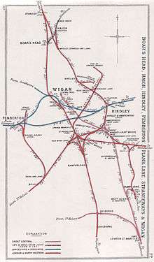
The station was on the Wigan Junction Railways line, known locally as the "Wigan Central line", which ran from Wigan Central to Glazebrook.[5][6] It was situated immediately north of the bridge over Crankwood Lane, which in 2015 was still a minor road.
From 1903 to 1915 the LNWR operated Plank Lane station a short distance to the east on the same country lane but on a different line.
Services
The service patterns in 1895, 1947 and 1962 are fully documented in the authoritative Disused Stations website.
In April 1884 the service pattern was straightforward. Six "Down" (towards Wigan) trains called from Manchester Central. In addition, one "express" called at Glazebrook only and passed West Leigh and Bedford without stopping. Of the six, three called at all stations, the remaining three missed some stations between Manchester and Glazebrook. With the exception of the "express" all trains called at all stations between Glazebrook and Wigan. The "Up" service was similar.[7]
In 1922 six "Down" trains called, All Stations from Manchester Central on "Weekdays" (Mondays to Saturdays), with a further evening train from Lowton St Mary's only. Three other trains called, apparently All Stations from Culcheth, but it is possible they originated from Liverpool Central or Warrington Central and turned west to north at Glazebrook West Junction. One of these trains ran on Fridays and Saturdays Only and the other two ran on Saturdays Only. The "Up" service was broadly similar, but the mix of Saturday Only trains was even more complicated. There was no Sunday service.[8]
The line through West Leigh and Bedford was also a diversionary route and a route by which traffic such as Summer Saturday holiday specials could bipass busy spots, such as Wigan. Pixton, for example, has a fine 1961 shot of a Summer Saturday Sheffield to Blackpool train at Lowton St Mary's which will pass through the station then bear right immediately north of Hindley South onto the Whelley Loop, joining the WCML at Standish, bypassing Wigan altogether.[9]
Opening, naming and closure
The line and station opened in 1884. Initially named "Plank Lane for West Leigh", the station was renamed "West Leigh and Bedford" in Summer 1893.[1] The station closed on 2 November 1964, when the line closed to passengers. The line closed to goods in 1968 and has since been lifted.
After closure
By 2006 the site had been razed to the ground. A lone gatepost remained as a reminder of the station.
| Preceding station | Disused railways | Following station | ||
|---|---|---|---|---|
| Bickershaw and Abram Line and station closed |
Great Central Railway Wigan Junction Railways |
Lowton St Mary's Line and station closed |
References
- Dow 1962, p. 194.
- Butt 1995.
- Quick 2009, p. 405.
- Sweeney 2013, pp. 41-61.
- Smith & Turner 2012, Map 45.
- Jowett 1989, Map 44.
- Dow 1962, p. 354.
- Bradshaw 1985, pp. 714–5
- Pixton 1996, p. 119.
Sources
- Bradshaw, George (1985) [July 1922]. Bradshaw's General Railway and Steam Navigation guide for Great Britain and Ireland: A reprint of the July 1922 issue. Newton Abbot: David and Charles. ISBN 978-0-7153-8708-5. OCLC 12500436.
- Butt, R. V. J. (1995). The Directory of Railway Stations: details every public and private passenger station, halt, platform and stopping place, past and present (1st ed.). Sparkford: Patrick Stephens Ltd. ISBN 978-1-85260-508-7. OCLC 60251199.
- Dow, George (1962). Great Central, Volume Two Dominion of Watkin 1864-1899. Shepperton: Ian Allan. ISBN 978-0-7110-1469-5. OCLC 655324061.
- Jowett, Alan (March 1989). Jowett's Railway Atlas of Great Britain and Ireland: From Pre-Grouping to the Present Day (1st ed.). Sparkford: Patrick Stephens Ltd. ISBN 978-1-85260-086-0. OCLC 22311137.
- Pixton, Bob (1996), The Archive Photographs Series Widnes and St Helens Railways, The Chalford Publishing Company, ISBN 978-0-7524-0751-7CS1 maint: ref=harv (link)
- Quick, Michael (2009) [2001]. Railway passenger stations in Great Britain: a chronology (4th ed.). Oxford: Railway and Canal Historical Society. ISBN 978-0-901461-57-5. OCLC 612226077.
- Smith, Paul; Turner, Keith (2012), Railway Atlas Then and Now, Ian Allan Publishing, ISBN 978-0-7110-3695-6CS1 maint: ref=harv (link)
- Sweeney, Dennis (2013). The Wigan Junction Railways. Leigh: Triangle Publishing. ISBN 978-0-9550030-5-9.CS1 maint: ref=harv (link)
External links
- "The station's history and services". Disused Stations.
- "The station on a 1948 OS Map". npe maps.
- "The station on a 1909 OS map". National Library of Scotland.
- "The station and line on overlain maps". Rail Map Online.
- "The line and mileages". railwaycodes.