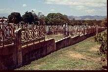
West End, Queensland (Townsville)
West End is an inner suburb of Townsville in the City of Townsville, Queensland, Australia.
| West End Townsville, Queensland | |||||||||||||||
|---|---|---|---|---|---|---|---|---|---|---|---|---|---|---|---|
| Population | 4,064 (2016 census)[1] | ||||||||||||||
| Postcode(s) | 4810 | ||||||||||||||
| LGA(s) | City of Townsville | ||||||||||||||
| State electorate(s) | Townsville | ||||||||||||||
| Federal Division(s) | Herbert | ||||||||||||||
| |||||||||||||||
Geography
West End is situated at the base of Castle Hill (the hill).
History

The first community cemetery is located in West End. A reflection of attitudes existing during the time it was in use, research has established that it was ethnically segregated. It has been reported that there are separate areas where, at least, Chinese and Aboriginal deceased were interred.
During World War 2, the massive Green Street bunker was used by the RAAF. It is now the State Emergency Service building.
Townsville West State School opened on 21 March 1887 and celebrated its centenary in 1987.[2][3]
St Mary's School opened on 1 October 1888 and closed on 16 July 1997.[4]
Townsville West Special School opened on 29 September 1958 and closed on 21 December 1992.[3]
In the 2011 census, West End had a population of 4,242 people.[5]
Heritage listings
St_Marys_Townsville.jpg)
West End has a number of heritage-listed sites, including:
- 5 Castling Street: Currajong (house)[6]
- Francis Street: West End Cemetery[7]
- Green Street: former RAAF Operations Building Site[8]
- 29 Ingham Road: Townsville West State School[9]
- 34 Ingham Road: St Mary's Church & Convent[10]
- 72-104 Ingham Road: Townsville Showground[11]
- 89 Ingham Road: West End Hotel[12]
- 95 Stagpole Street: Wolverton[13]
References
- Australian Bureau of Statistics (27 June 2017). "West End (Townsville - Qld) (State Suburb)". 2016 Census QuickStats. Retrieved 18 April 2018.

- Stuart, Ann; Townsville West State School (1987), Townsville West State School centenary 1887-1987, Townsville West State School, retrieved 3 February 2018
- "Opening and closing dates of Queensland Schools". Queensland Government. Retrieved 18 April 2019.
- Queensland Family History Society (2010), Queensland schools past and present (Version 1.01 ed.), Queensland Family History Society, ISBN 978-1-921171-26-0
- Australian Bureau of Statistics (31 October 2012). "West End". 2011 Census QuickStats. Retrieved 31 January 2016.

- "Currajong (entry 600884)". Queensland Heritage Register. Queensland Heritage Council. Retrieved 16 July 2013.
- "West End Cemetery (entry 601475)". Queensland Heritage Register. Queensland Heritage Council. Retrieved 16 July 2013.
- "RAAF Operations Building Site (former) (entry 602260)". Queensland Heritage Register. Queensland Heritage Council. Retrieved 16 July 2013.
- "Townsville and District Education Centre and Memorial Gates (entry 602049)". Queensland Heritage Register. Queensland Heritage Council. Retrieved 16 July 2013.
- "St Mary's Church & former Convent (entry 600879)". Queensland Heritage Register. Queensland Heritage Council. Retrieved 16 July 2013.
- "Townsville Showground (entry 602650)". Queensland Heritage Register. Queensland Heritage Council. Retrieved 16 July 2013.
- "West End Hotel (entry 601028)". Queensland Heritage Register. Queensland Heritage Council. Retrieved 16 July 2013.
- "Wolverton (entry 600927)". Queensland Heritage Register. Queensland Heritage Council. Retrieved 16 July 2013.