Weiskirchen
Weiskirchen is a municipality in the district Merzig-Wadern, in Saarland, Germany. It is situated in the Hunsrück, approx. 20 km northeast of Merzig, and 25 km southeast of Trier.
Weiskirchen | |
|---|---|
 Coat of arms | |
Location of Weiskirchen within Merzig-Wadern district 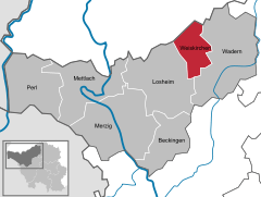  | |
 Weiskirchen  Weiskirchen | |
| Coordinates: 49°33′22″N 6°49′12″E | |
| Country | Germany |
| State | Saarland |
| District | Merzig-Wadern |
| Subdivisions | 5 |
| Government | |
| • Mayor | Werner Hero (CDU) |
| Area | |
| • Total | 33.64 km2 (12.99 sq mi) |
| Highest elevation | 700 m (2,300 ft) |
| Lowest elevation | 300 m (1,000 ft) |
| Population (2018-12-31)[1] | |
| • Total | 6,313 |
| • Density | 190/km2 (490/sq mi) |
| Time zone | CET/CEST (UTC+1/+2) |
| Postal codes | 66707–66709 |
| Dialling codes | 06876 |
| Vehicle registration | MZG |
| Website | www.weiskirchen.de |
Geography
Location
Weiskirchen is located in the west of the Black Forest.
Districts
- Konfeld
- Rappweiler-Zwalbach
- Thailen
- Weierweiler
- Weiskirchen
Sights
In Rappweiler is the "Wild and hiking park Weiskirchen-Rappweiler", whose stock consists mainly of red deer. In the park is also the information center of the Saar-Hunsrück Nature Park with a permanent exhibition.
Towns and municipalities in Merzig-Wadern | ||
|---|---|---|
Coat of arms | ||
gollark: ++magic py __builtins__.keys()
gollark: ++magic py dir(__builtins__)
gollark: ++magic py raise ValueError("APIOFORM")
gollark: ++exec raise ValueError("APIOFORM")
gollark: ++apioform
References
- "Saarland.de – Amtliche Einwohnerzahlen Stand 31.12.2018" (PDF). Statistisches Amt des Saarlandes (in German). June 2019.
This article is issued from Wikipedia. The text is licensed under Creative Commons - Attribution - Sharealike. Additional terms may apply for the media files.