Weißenborn, Hesse
Weißenborn (or Weissenborn) is a community in the Werra-Meißner-Kreis in Hesse, Germany.
Weißenborn | |
|---|---|
Location of Weißenborn within Werra-Meißner-Kreis district 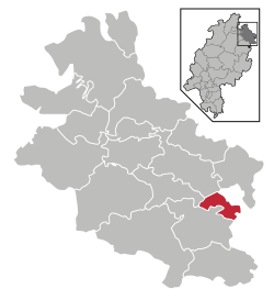 | |
 Weißenborn  Weißenborn | |
| Coordinates: 51°07′N 10°07′E | |
| Country | Germany |
| State | Hesse |
| Admin. region | Kassel |
| District | Werra-Meißner-Kreis |
| Government | |
| • Mayor | Thomas Mäurer (Ind.) |
| Area | |
| • Total | 15.6 km2 (6.0 sq mi) |
| Elevation | 280 m (920 ft) |
| Population (2018-12-31)[1] | |
| • Total | 981 |
| • Density | 63/km2 (160/sq mi) |
| Time zone | CET/CEST (UTC+1/+2) |
| Postal codes | 37299 |
| Dialling codes | 05659 |
| Vehicle registration | ESW |
| Website | www.gemeinde-weissenborn.de |
Geography
Location
Weißenborn lies in the North Hesse Uplands some 8 km (as the crow flies) southeast of Eschwege and abuts a section of the boundary with Thuringia. It is found in the Schlierbachswald, onto which borders the Ringgau (ranges) not far south of the community. Not far southwest of Weißenborn (elevation: 280 m above sea level) stands the Rabenkuppe (514.8 m above sea level), and just under 6 km (as the crow flies) east of the community, on the Thuringian side of the state boundary, is the Heldrastein (503.8 m above sea level).
Neighbouring communities
Weißenborn borders in the north on the town of Treffurt, in the east on the community of Ifta (both in Thuringia’s Wartburgkreis), in the south on the community of Ringgau, in the west on the community of Wehretal and in the northwest on the town of Eschwege (all three in the Werra-Meißner-Kreis).
Constituent communities
Weißenborn’s Ortsteile are Weißenborn and Rambach.
History
Archaeological finds bear witness to people having lived in the area that is now Weißenborn as early as about 2000 BC. The community itself had its first documentary mention in 1365.
Politics
Community council
The municipal election held on 26 March 2006 yielded the following results:
| Parties and voter communities | % 2006 |
Seats 2006 |
% 2001 |
Seats 2001 | |
| CDU | Christian Democratic Union of Germany | 22.9 | 3 | 21.9 | 3 |
| SPD | Social Democratic Party of Germany | 53.9 | 8 | 51.2 | 8 |
| FWG | Freie Wählergemeinschaft Weißenborn und Rambach | 23.2 | 4 | 26.9 | 4 |
| Total | 100.0 | 15 | 100.0 | 15 | |
| Voter turnout in % | 72.0 | 71.6 | |||
Economy and infrastructure
Transport
Over Bundesstraßen 7 (Kassel-Eisenach) and 250 (Wanfried-Creuzburg), the community is linked to the highway network.
Towns and municipalities in Werra-Meißner-Kreis district | ||
|---|---|---|
Wappen des Landkreises Werra-Meißner-Kreis | ||
References
- "Bevölkerungsstand am 31.12.2018". Hessisches Statistisches Landesamt (in German). July 2019.