Watervale, South Australia
Watervale is a town on the Horrocks Highway in the Clare Valley, South Australia, approximately 9 kilometres north of Auburn and 15 kilometres south of Clare. It is surrounded by a number of small wineries and several B&Bs. The Riesling Trail runs past the town to the west, between the Highway and the Skilly Hills. The town has a number of 19th-century heritage buildings, including the former Stanley Grammar School, which now provides private bed and breakfast accommodation.[3]
| Watervale South Australia | |||||||||||||||
|---|---|---|---|---|---|---|---|---|---|---|---|---|---|---|---|
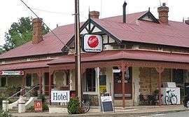 The Watervale Hotel, Watervale | |||||||||||||||
 Watervale | |||||||||||||||
| Coordinates | 33°57′0″S 138°38′0″E | ||||||||||||||
| Population | 326 (2016 census)[1] | ||||||||||||||
| Established | 1847 | ||||||||||||||
| Postcode(s) | 5452 | ||||||||||||||
| Location | |||||||||||||||
| LGA(s) | District Council of Clare and Gilbert Valleys | ||||||||||||||
| Region | Mid North | ||||||||||||||
| State electorate(s) | Frome | ||||||||||||||
| Federal Division(s) | Grey[2] | ||||||||||||||
| |||||||||||||||
History
Watervale is located on Eyre Creek, which is a tributary of the Wakefield River. The area on which the town was settled was originally granted to a pioneer named David Davies in 1847 by Governor Robe, and he named this section of land Watervale.[4]
The area was settled by a number of Protestant families who founded a Bible Methodist Church in the township. The current Uniting Church and accompanying hall are examples of such colonial constructions in the area.
The town today
The township boasts a general store and Post Office, Hotel, Primary School, CFS unit, Anglican and Uniting churches, a garage, a small number of local businesses, wineries, and a variety of recreational facilities at the "Watervale Soldiers' Memorial Park" (tennis club, tennis courts and a bowling green). Several Bed and Breakfast and Holiday Cottages are available for rent, including Watervale Retreat, Battunga B&B, Quince Cottage. The town can be readily accessed from the Riesling Trail. The historic Grandstand overlooking the town oval was renovated in 2010.
As part of the Clare Valley, the area is known for Riesling. Cabernet and Shiraz wines are also produced. Local wineries include Crabtree Watervale Wines, Stephen John Wines and Annie's Lane.
A local artist of note is Harry Sherwin.[5]
Watervale hosts an annual 'Day on the Green' concert at Annie's Lane, attracting up to 6,000 concert-goers.
The Watervale Foresters Hall, which in more recent years had been used by the community for meetings, art classes and a children's playgroup, had by 2009 fallen into disrepair. It was subsequently sold by the Watervale Community Association following considerable controversy and is now in private ownership.[6]
Governance
Watervale is in the District Council of Clare and Gilbert Valleys, the state electoral district of Frome, and the Australian House of Representatives Division of Grey.[2]
.jpg)
See also
References
- Australian Bureau of Statistics (27 June 2017). "Watervale". 2016 Census QuickStats.

- "Federal electoral division of Grey, boundary gazetted 20 July 2018". Australian Electoral Commission. Retrieved 12 April 2019.
- Accommodation, Clare Valley. "Clare Valley Accommodation". www.oldstanleygrammar.com.au. Retrieved 18 January 2017.
- Rodney Cockburn (1984) [1908]. What's in a name? Nomenclature of South Australia. Fergusson Publications.
- "Harry Sherwin. Artist. Watervale, South Australia". harrysherwin.com. Retrieved 18 January 2017.
- Media, Australian Community Media - Fairfax (2 July 2014). "Community hall sold". Northern Argus. Retrieved 18 January 2017.
| Wikimedia Commons has media related to Watervale, South Australia. |