Wat Sing District
Wat Sing (Thai: วัดสิงห์, pronounced [wát sǐŋ]) is a district (amphoe) in the northern part of Chai Nat Province, central Thailand.
Wat Sing วัดสิงห์ | |
|---|---|
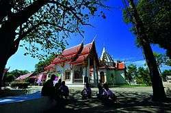
 Wat Pak Khlong Makham Thao in tambon Makham Thao | |
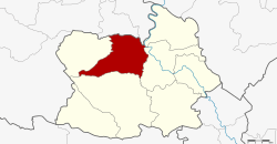
 District location in Chai Nat Province | |
| Coordinates: 15°15′19″N 100°2′17″E | |
| Country | Thailand |
| Province | Chai Nat |
| Seat | Makham Thao |
| Area | |
| • Total | 315.318 km2 (121.745 sq mi) |
| Population (2008) | |
| • Total | 2,632,789 |
| • Density | 83.5/km2 (216/sq mi) |
| Time zone | UTC+7 (ICT) |
| Postal code | 17120 |
| Geocode | 1803 |
Geography
Neighboring districts are (from the northeast clockwise) Manorom, Mueang Chai Nat, Hankha and Nong Mamong of Chai Nat Province; Nong Khayang and Mueang Uthai Thani of Uthai Thani Province.
Administration
The district is divided into seven sub-districts (tambons), which are further subdivided into 47 villages (mubans). Wat Sing is a sub-district municipality (thesaban tambon) which covers tambon Wat Sing. There are a further six tambon administrative organizations (TAO).
| No. | Name | Thai | Villages | Pop.[1] |
|---|---|---|---|---|
| 1. | Wat Sing | วัดสิงห์ | - | 4,028 |
| 2. | Makham Thao | มะขามเฒ่า | 11 | 5,174 |
| 3. | Nong Noi | หนองน้อย | 8 | 3,744 |
| 4. | Nong Bua | หนองบัว | 5 | 2,755 |
| 6. | Nong Khun | หนองขุ่น | 8 | 3,443 |
| 7. | Bo Rae | บ่อแร่ | 7 | 2,886 |
| 11. | Wang Man | วังหมัน | 8 | 4,359 |
Missing numbers are tambon which now form Nong Mamong District.
gollark: · · ·
gollark: So you can kill people without living family? Fun!
gollark: Apparently people like "negative average preference utilitarianism", where you have to produce the least average amount of dissatisfied preferences.
gollark: Do we *really*?
gollark: The "arithmetic mean".
References
- "Population statistics 2008". Department of Provincial Administration.
External links
- amphoe.com (Thai)
This article is issued from Wikipedia. The text is licensed under Creative Commons - Attribution - Sharealike. Additional terms may apply for the media files.