Noen Kham District
Noen Kham (Thai: เนินขาม, pronounced [nɤ̄ːn kʰǎːm]) is the southwesternmost district (amphoe) of Chai Nat Province, central Thailand.
Noen Kham เนินขาม | |
|---|---|
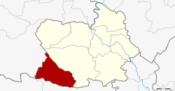 District location in Chai Nat Province | |
| Coordinates: 14°57′44″N 99°54′42″E | |
| Country | Thailand |
| Province | Chai Nat |
| Seat | Noen Kham |
| District established | 1997 |
| Area | |
| • Total | 270.0 km2 (104.2 sq mi) |
| Population (2008) | |
| • Total | 17,371 |
| • Density | 64.6/km2 (167/sq mi) |
| Time zone | UTC+7 (ICT) |
| Postal code | 17130 |
| Geocode | 1808 |
History
The two tambons Noen Kham and Kabok Tia of Hankha District were separated and created the new minor district (king amphoe) on 1 July 1997.[1]
On 15 May 2007, all 81 minor districts were upgraded to full districts.[2] With publication in the Royal Gazette on 24 August the upgrade became official. [3]
Geography
Neighboring districts are (from the north clockwise) Hankha of Chainat Province; Doem Bang Nang Buat and Dan Chang of Suphanburi Province; and Ban Rai of Uthai Thani Province.
Administration
The district is divided into three sub-districts (tambons), which are further subdivided into 48 villages (mubans). There are no municipal (thesaban) areas, and three tambon administrative organizations (TAO).
| No. | Name | Thai | Pop.[4] | |
|---|---|---|---|---|
| 1. | Noen Kham | เนินขาม | 19 | 6,355 |
| 2. | Kabok Tia | กะบกเตี้ย | 15 | 5,523 |
| 3. | Suk Duean Ha | สุขเดือนห้า | 14 | 5,493 |
References
- ประกาศกระทรวงมหาดไทย เรื่อง แบ่งเขตท้องที่อำเภอหันคา จังหวัดชัยนาท ตั้งเป็นกิ่งอำเภอเนินขาม (PDF). Royal Gazette (in Thai). 114 (Special 51 ง): 7. June 25, 1997.
- แถลงผลการประชุม ครม. ประจำวันที่ 15 พ.ค. 2550 (in Thai). Manager Online.
- พระราชกฤษฎีกาตั้งอำเภอฆ้องชัย...และอำเภอเหล่าเสือโก้ก พ.ศ. ๒๕๕๐ (PDF). Royal Gazette (in Thai). 124 (46 ก): 14–21. August 24, 2007.
- "Population statistics 2008". Department of Provincial Administration. Archived from the original on 2012-08-19.