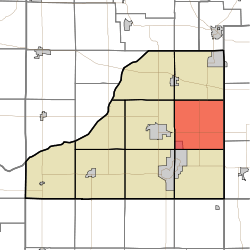
Washington Township, Starke County, Indiana
Washington Township is one of nine townships in Starke County, in the U.S. state of Indiana.[2] As of the 2010 census, its population was 3,003 and it contained 1,201 housing units.[3]
Washington Township | |
|---|---|
 Location in Starke County | |
| Coordinates: 41°17′56″N 86°31′19″W | |
| Country | |
| State | |
| County | Starke |
| Government | |
| • Type | Indiana township |
| Area | |
| • Total | 36.19 sq mi (93.7 km2) |
| • Land | 36.13 sq mi (93.6 km2) |
| • Water | 0.06 sq mi (0.2 km2) 0.17% |
| Elevation | 722 ft (220 m) |
| Population (2010) | |
| • Total | 3,003 |
| • Density | 83.1/sq mi (32.1/km2) |
| Time zone | UTC-6 (Central (CST)) |
| • Summer (DST) | UTC-5 (CDT) |
| ZIP codes | 46511, 46531, 46534 |
| Area code(s) | 574 |
| GNIS feature ID | 454020 |
Geography
According to the 2010 census, the township has a total area of 36.19 square miles (93.7 km2), of which 36.13 square miles (93.6 km2) (or 99.83%) is land and 0.06 square miles (0.16 km2) (or 0.17%) is water.[3]
Cities, towns, villages
- Bass Lake (north edge)
Unincorporated towns
(This list is based on USGS data and may include former settlements.)
Adjacent townships
- Oregon Township (north)
- West Township, Marshall County (east)
- Union Township, Marshall County (southeast)
- North Bend Township (south)
- California Township (southwest)
- Center Township (west)
- Davis Township (northwest)
Cemeteries
The township contains these two cemeteries: Holy Cross and Swartzell.
Lakes
- Eagle Lake
School districts
- Knox Community School Corporation
Political districts
- Indiana's 2nd congressional district
- State House District 17
- State Senate District 5
gollark: Ah, but #3 refers to my "previous submission". But I didn't actually have one, strictly speaking, since helloboi messed up round 4.
gollark: Well, I did write *all* of them, by some definitions.
gollark: Did you accidentally use the GTech™ atemporal VPN?
gollark: Most won't so this would look bad.
gollark: Or use the "site themes" mode.
References
- United States Census Bureau 2008 TIGER/Line Shapefiles
- United States Board on Geographic Names (GNIS)
- IndianaMap
- "US Board on Geographic Names". United States Geological Survey. October 25, 2007. Retrieved 2017-05-09.
- "Washington Township". Geographic Names Information System. United States Geological Survey. Retrieved 2009-07-05.
- "Population, Housing Units, Area, and Density: 2010 - County -- County Subdivision and Place -- 2010 Census Summary File 1". United States Census. Archived from the original on 2020-02-12. Retrieved 2013-05-10.
This article is issued from Wikipedia. The text is licensed under Creative Commons - Attribution - Sharealike. Additional terms may apply for the media files.