Railroad Township, Starke County, Indiana
Railroad Township is one of nine townships in Starke County, in the U.S. state of Indiana.[2] As of the 2010 census, its population was 1,226 and it contained 549 housing units.[3]
Railroad Township | |
|---|---|
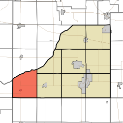 Location in Starke County | |
| Coordinates: 41°12′59″N 86°51′58″W | |
| Country | |
| State | |
| County | Starke |
| Government | |
| • Type | Indiana township |
| Area | |
| • Total | 36.65 sq mi (94.9 km2) |
| • Land | 36.61 sq mi (94.8 km2) |
| • Water | 0.04 sq mi (0.1 km2) 0.11% |
| Elevation | 673 ft (205 m) |
| Population (2010) | |
| • Total | 1,226 |
| • Density | 33.5/sq mi (12.9/km2) |
| Time zone | UTC-6 (Central (CST)) |
| • Summer (DST) | UTC-5 (CDT) |
| ZIP codes | 46366, 46374 |
| Area code(s) | 219 |
| GNIS feature ID | 453779 |
Geography
According to the 2010 census, the township has a total area of 36.65 square miles (94.9 km2), of which 36.61 square miles (94.8 km2) (or 99.89%) is land and 0.04 square miles (0.10 km2) (or 0.11%) is water.[3] It is bordered on the north by the Kankakee River.
Cities, towns, villages
Unincorporated towns
(This list is based on USGS data and may include former settlements.)
Adjacent townships
- Dewey Township, LaPorte County (north)
- Jackson Township (northeast)
- Prairie Township, LaPorte County (northeast)
- Wayne Township (east)
- Rich Grove Township, Pulaski County (southeast)
- Cass Township, Pulaski County (south)
- Walker Township, Jasper County (southwest)
- Kankakee Township, Jasper County (west)
- Pleasant Township, Porter County (northwest)
Cemeteries
The township contains All Saints Cemetery.
School districts
- North Judson-San Pierre School Corporation
Political districts
- Indiana's 2nd congressional district
- State House District 17
- State Senate District 5
gollark: What if I store all user data in large files uploaded to Discord and make it THEIR problem?
gollark: Discord could even send me emails at the scale ABR operates at, I assume.
gollark: Well that would be hilariously inefficient and annoying. Hmmm.
gollark: Wait, how can I *know* if someone deletes their account?
gollark: I suppose I'll avoid storing actual message content except for opted in users.
References
- United States Census Bureau 2008 TIGER/Line Shapefiles
- United States Board on Geographic Names (GNIS)
- IndianaMap
- "US Board on Geographic Names". United States Geological Survey. October 25, 2007. Retrieved 2017-05-09.
- "Railroad Township". Geographic Names Information System. United States Geological Survey. Retrieved 2009-07-05.
- "Population, Housing Units, Area, and Density: 2010 - County -- County Subdivision and Place -- 2010 Census Summary File 1". United States Census. Archived from the original on 2020-02-12. Retrieved 2013-05-10.
External links
Places adjacent to Railroad Township, Starke County, Indiana | |
|---|---|
Municipalities and communities of Starke County, Indiana, United States | ||
|---|---|---|
| City | Map of Indiana highlighting Starke County | |
| Towns | ||
| Townships | ||
| CDPs | ||
| Other unincorporated communities | ||
| Footnotes | ‡This populated place also has portions in an adjacent county or counties | |
This article is issued from Wikipedia. The text is licensed under Creative Commons - Attribution - Sharealike. Additional terms may apply for the media files.