Washington State Route 224
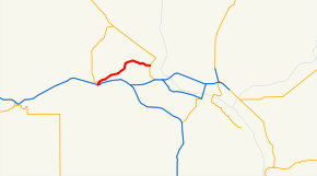
State Route 224 (SR 224) is a 10.15-mile (16.33 km) long state highway located entirely in Benton County, Washington, United States. The highway serves to connect SR 225 to Interstate 82 (I-82) and U.S. Route 12 (US 12), and to link Benton City to West Richland and Richland. Before the 1964 state highway renumbering the highway was numbered Secondary State Highway 3R. SR 224 is a lightly traveled rural highway except through Richland, where an average of 16,000 cars traveled the highway daily in 2009. The Washington State Department of Transportation (WSDOT) rebuilt its southern terminus as a roundabout in 2016, as part of a project to improve traffic congestion near the Red Mountain AVA.
| ||||
|---|---|---|---|---|
 | ||||
| Route information | ||||
| Auxiliary route of SR 22 | ||||
| Defined by RCW 47.17.435 | ||||
| Maintained by WSDOT | ||||
| Length | 10.15 mi[1] (16.33 km) | |||
| Existed | 1965–present | |||
| Major junctions | ||||
| West end | ||||
| East end | ||||
| Location | ||||
| Counties | Benton | |||
| Highway system | ||||
| ||||

Route description
SR 224 begins at an interchange with I-82 in southern Benton City. After only 0.05 mi (80 m), SR 224 intersects SR 225 at a roundabout and turns to the east—becoming Kennedy Road once it leaves Benton City limits. After passing a park and ride lot on the south side of the highway, the road turns back to the north off of Kennedy road, paralleling the Yakima River, slowly turning northeast through a rural area of Benton County. After passing through farmland SR 224 enters West Richland and becomes Van Giesen Street, the main east–west thoroughfare of the city.[2] Exiting the town, the highway passes over the Yakima River and enters Richland, passing through a rural area on the south side of Richland Airport. At the southeast corner of the airport, SR 224 crosses over a single track belonging to the Port of Benton and managed by Tri-City Railroad and terminates at an intersection with SR 240 (the Richland Bypass Highway).[3] Van Giesen Street continues east from the terminus of SR 224 for another 1.7 miles (2.7 km), intersecting SR 240 Business near the western shore of the Columbia River.[4]
The highway is primarily a two-lane road between Benton City and West Richland. The road expands to four lanes in West Richland, a width the highway remains to its terminus in Richland. Speed limits posted on the highway range from 30 miles per hour (48 km/h) to 55 miles per hour (89 km/h).[1] Every year WSDOT conducts a series of surveys on its highways in the state to measure traffic volume. This is expressed in terms of average annual daily traffic (AADT), which is a measure of traffic volume for any average day of the year. In 2009, WSDOT calculated that as few as 3,200 cars traveled through the intersection at Keene Road, west of West Richland, and as many as 16,000 cars at the eastern terminus.[5]
History
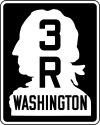
A roadway has connected Benton City to Richland since at least 1926,[6] while a road with an alignment more similar to that of the current highway first appeared on maps in 1939, with termini at the concurrent highways U.S. Route 410 and PSH 3. The highway now known as SR 224 was numbered Secondary State Highway 3R (SSH 3R) between 1937 and the 1964 state highway renumbering,[7] which abolished the Primary and Secondary highway numbers, replacing them with Sign Route numbers, later renamed State Routes.
The twin set of bridges that carry I-82 over the highway at the western terminus were built in 1973,[8] which was during the initial construction of I-82 through southern Washington.[9] The current bridge that carries SR 224 over the Yakima River was constructed in 1993,[10] replacing the original bridge on the highway.
The highway's southern terminus, at I-82 and SR 225, was converted into a roundabout in June 2016 to improve traffic flow. The $4.5 million project was the first project funded by the Connecting Washington tax package, passed in 2015 by the state legislature.[11] A road connecting SR 224 near the Red Mountain AVA to the a new interchange on I-82 is planned to begin construction in 2019 and will cost $24.9 million.[12]
Major intersections
The entire highway is in Benton County.
| Location | mi[1] | km | Destinations | Notes | |
|---|---|---|---|---|---|
| Benton City | 0.00– 0.04 | 0.00– 0.064 | I-82 exit 96; interchange, western terminus. | ||
| 0.05– 0.06 | 0.080– 0.097 | ||||
| Richland | 10.13– 10.15 | 16.30– 16.33 | Eastern terminus | ||
| 1.000 mi = 1.609 km; 1.000 km = 0.621 mi | |||||
References
- "State Highway Log Planning Report 2009 SR 2 to SR 971" (PDF). Washington State Department of Transportation (WSDOT). p. 1241. Retrieved October 27, 2010.
- "Benton County Web Map". Benton County GIS Department. Retrieved October 25, 2018.
- 2013 Washington State Rail System (PDF) (Map). Washington State Department of Transportation. February 2014. Retrieved December 13, 2015.
- Google (November 18, 2010). "Van Giesen Street" (Map). Google Maps. Google. Retrieved November 18, 2010.
- "2009 Annual Traffic Report" (PDF). WSDOT. p. 162. Retrieved October 28, 2010.
- Horse Haven Quadrangle (Map). Cartography by Brokaw, S. E. Automobile Club of Washington. 1926. Retrieved October 28, 2010.
- "Sign Route Numbers with Corresponding Legislative Highway Numbers" (PDF). Washington State Department of Highways. December 1, 1965. p. 9. Retrieved October 28, 2010.
- "0009444D0000000". National Bridge Inventory. Federal Highway Administration. Retrieved November 18, 2010.
- Washington Oregon Road Map (Map). 1 in ≈ 17.3 mi. Cartography by Rand McNally. Union 76. 1972. § H12.
- "0014085A0000000". National Bridge Inventory. Federal Highway Administration. Retrieved November 18, 2010.
- Culverwell, Wendy (June 13, 2016). "New Benton City roundabout is first funded by new gas tax". Tri-City Herald. Retrieved June 17, 2018.
- "Red Mountain Transportation Improvements" (PDF). Washington State Department of Transportation. August 2015. Retrieved June 17, 2018.
External links
| Wikimedia Commons has media related to Washington State Route 224. |