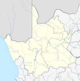
Warrenton, Northern Cape
Warrenton is an agricultural town of approximately 18,000 people in the Northern Cape province of South Africa, situated 70 kilometres (40 mi) north of Kimberley on the Vaal River.
Warrenton | |
|---|---|
Railway bridge across the Vaal River at Warrenton | |
 Warrenton  Warrenton | |
| Coordinates: 28°06′41″S 24°50′59″E | |
| Country | South Africa |
| Province | Northern Cape |
| District | Frances Baard |
| Municipality | Magareng |
| Established | 1880 |
| Area | |
| • Total | 31.7 km2 (12.2 sq mi) |
| Elevation | 1,180 m (3,870 ft) |
| Population (2011)[1] | |
| • Total | 22,588 |
| • Density | 710/km2 (1,800/sq mi) |
| Racial makeup (2011) | |
| • Black African | 79.6% |
| • Coloured | 14.2% |
| • Indian/Asian | 0.7% |
| • White | 5.1% |
| • Other | 0.3% |
| First languages (2011) | |
| • Tswana | 66.7% |
| • Afrikaans | 21.7% |
| • Xhosa | 3.8% |
| • Sotho | 2.0% |
| • Other | 5.8% |
| Time zone | UTC+2 (SAST) |
| Postal code (street) | 8530 |
| PO box | 8530 |
| Area code | 053 |
History
In 1880, a syndicate bought the western portion of the farm Grasbult to irrigate the fertile land and produce vegetables for the diamond fields. The town which grew here was named after Sir Charles Warren. Diamonds were discovered here in 1888 and mining continued to 1926.
Geography
Warrenton is situated in the north-eastern part of the Northern Cape province, on the south bank of the Vaal River, approximately 70 kilometres (40 mi) north of Kimberley, the provincial capital.
The town lies just downstream of the Vaalharts Dam, which supplies water to the Vaalharts Irrigation Scheme.
The N12 national road, the main route from Kimberley to Gauteng, passes through Warrenton, and the N18 national road to Mafikeng and Botswana begins there.
The main Cape Town–Kimberley–Johannesburg railway line also passes through the town, and the line to Mafikeng and Botswana branches off at Fourteen Streams, on the north bank of the Vaal opposite Warrenton.
Demographics
In the 2011 Census the population of Warrenton, including the township of Ikutseng, was recorded as 22,588 people living in 5,615 households. 80% of the residents described themselves as "Black African", 14% as "Coloured", 5% as "White", and 1% as "Indian or Asian". 67% of the residents of the town speak Setswana as their first language, while 22% speak Afrikaans, 4% speak Xhosa and 2% speak Sotho.[1]
Government
Warrenton is the only town in the Magareng Local Municipality, which covers an area of 1,542 square kilometres (595 sq mi) between the Harts River and the Free State border. The municipal council is controlled by an African National Congress majority; the mayor is Neo Mase.[2]
References
- Sum of the Main Places Ikhutseng and Warrenton from Census 2011.
- "Contact information: Magareng Local Municipality". Government Communication and Information System. Retrieved 13 January 2014.
External links
- Warrenton at the Northern Cape Tourism Authority website
.svg.png)