Wakulla County Airport
Wakulla County Airport (FAA LID: 2J0) is a county-owned, public-use airport in Wakulla County, Florida, United States. It is located three nautical miles (6 km) south of the central business district of Panacea, Florida.[1]
Wakulla County Airport | |||||||||||
|---|---|---|---|---|---|---|---|---|---|---|---|
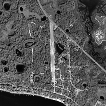 USGS 1999 orthophoto | |||||||||||
| Summary | |||||||||||
| Airport type | Public | ||||||||||
| Owner | Wakulla County | ||||||||||
| Serves | Panacea, Florida | ||||||||||
| Elevation AMSL | 11 ft / 3 m | ||||||||||
| Coordinates | 29°59′22″N 084°23′43″W | ||||||||||
| Runways | |||||||||||
| |||||||||||
| Statistics (2010) | |||||||||||
| |||||||||||
This general aviation airport is open to the public, although pilots are required to call ahead to be allowed ground access.
Facilities and aircraft
Wakulla County Airport covers an area of 15 acres (6 ha) at an elevation of 11 feet (3 m) above mean sea level. It has one runway designated 18/36 with a turf surface measuring 2,590 by 70 feet (789 x 21 m).[1]
For the 12-month period ending March 26, 2010, the airport had 5,475 general aviation aircraft operations, an average of 15 per day. At that time there were 10 aircraft based at this airport: 90% single-engine and 10% ultralight.[1]
References
- FAA Airport Master Record for 2J0 (Form 5010 PDF). Federal Aviation Administration. Effective May 31, 2012.
External links
- "Wakulla County Airport". brochure from CFASPP
- Resources for this airport:
- FAA airport information for 2J0
- AirNav airport information for 2J0
- FlightAware airport information and live flight tracker
- SkyVector aeronautical chart for 2J0