Virginia State Route 182
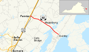
State Route 182 (SR 182) is a primary state highway in the U.S. state of Virginia. The state highway runs 3.71 miles (5.97 km) from U.S. Route 13 (US 13) in Painter east to SR 605 at Quinby in southern Accomack County.
| ||||
|---|---|---|---|---|
 | ||||
| Route information | ||||
| Maintained by VDOT | ||||
| Length | 3.71 mi[1] (5.97 km) | |||
| Existed | 1933–present | |||
| Major junctions | ||||
| West end | ||||
| East end | ||||
| Location | ||||
| Counties | Accomack | |||
| Highway system | ||||
| ||||

Route description
_at_U.S._Route_13_(Lankford_Highway)_in_Painter%2C_Accomack_County%2C_Virginia.jpg)
SR 182 begins at an intersection with US 13 (Lankford Highway) in the town of Painter. The state highway follows two-lane undivided Main Street very briefly east of US 13, during which the highway intersects an inactive railroad line. East of the inactive rail line, SR 182 turns north onto Railroad Avenue, then veers east onto Edmunds Street. The state highway leaves town along Mappsburg Road, which the highway follows to the hamlet of Mappsburg. SR 182 continues east as Quinby Bridge Road, which crosses the Machipongo River on the namesake bridge. The state highway reaches its eastern terminus at SR 605, which heads north as Bradfords Neck Road and south as Upshur Neck Road through the village of Quinby on Upshur Bay.[1][2]
Major intersections
The entire route is in Accomack County.
| Location | mi[1] | km | Destinations | Notes | |
|---|---|---|---|---|---|
| Painter | 0.00 | 0.00 | |||
| Quinby | 3.71 | 5.97 | |||
| 1.000 mi = 1.609 km; 1.000 km = 0.621 mi | |||||
References
- "2010 Traffic Data". Virginia Department of Transportation. 2010. Retrieved 2011-11-25.
- Accomack County (PDF)
- Google (2011-11-25). "Virginia State Route 182" (Map). Google Maps. Google. Retrieved 2011-11-25.
External links
| Wikimedia Commons has media related to Virginia State Route 182. |
| < SR 529 | District 5 State Routes 1928–1933 |
SR 531 > |