Virgil, Kansas
Virgil is a city in Greenwood County, Kansas, United States. As of the 2010 census, the city population was 71.[7]
Virgil, Kansas | |
|---|---|
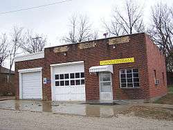 City Hall (2005) | |
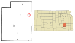 Location within Greenwood County and Kansas | |
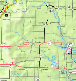 KDOT map of Greenwood County (legend) | |
| Coordinates: 37°58′50″N 96°0′40″W | |
| Country | United States |
| State | Kansas |
| County | Greenwood |
| Incorporated | 1922 [1] |
| Named for | Virgil, New York |
| Government | |
| • Type | Mayor–Council |
| Area | |
| • Total | 0.56 sq mi (1.46 km2) |
| • Land | 0.56 sq mi (1.45 km2) |
| • Water | 0.00 sq mi (0.01 km2) |
| Elevation | 1,004 ft (306 m) |
| Population | |
| • Total | 71 |
| • Estimate (2019)[4] | 63 |
| • Density | 112.50/sq mi (43.45/km2) |
| Time zone | UTC-6 (CST) |
| • Summer (DST) | UTC-5 (CDT) |
| ZIP code | 66870 |
| Area code | 620 |
| FIPS code | 20-74075 [5] |
| GNIS|GNIS ID | 0474448 [6] |
History
The first post office in Virgil was established in 1863.[8] The community may be named after Virgil, New York.[9]
Geography
Virgil is located at 37°58′50″N 96°0′40″W (37.980603, -96.011090).[10] According to the United States Census Bureau, the city has a total area of 0.56 square miles (1.45 km2), all of it land.[11]
Climate
The climate in this area is characterized by hot, humid summers and generally mild to cool winters. According to the Köppen Climate Classification system, Virgil has a humid subtropical climate, abbreviated "Cfa" on climate maps.[12]
Demographics
| Historical population | |||
|---|---|---|---|
| Census | Pop. | %± | |
| 1880 | 44 | — | |
| 1930 | 598 | — | |
| 1940 | 494 | −17.4% | |
| 1950 | 354 | −28.3% | |
| 1960 | 229 | −35.3% | |
| 1970 | 179 | −21.8% | |
| 1980 | 169 | −5.6% | |
| 1990 | 91 | −46.2% | |
| 2000 | 113 | 24.2% | |
| 2010 | 71 | −37.2% | |
| Est. 2019 | 63 | [4] | −11.3% |
| U.S. Decennial Census | |||
2010 census
As of the census[3] of 2010, there were 71 people, 35 households, and 21 families residing in the city. The population density was 126.8 inhabitants per square mile (49.0/km2). There were 57 housing units at an average density of 101.8 per square mile (39.3/km2). The racial makeup of the city was 95.8% White, 1.4% Native American, and 2.8% from two or more races.
There were 35 households of which 22.9% had children under the age of 18 living with them, 42.9% were married couples living together, 2.9% had a female householder with no husband present, 14.3% had a male householder with no wife present, and 40.0% were non-families. 34.3% of all households were made up of individuals and 28.5% had someone living alone who was 65 years of age or older. The average household size was 2.03 and the average family size was 2.57.
The median age in the city was 55.8 years. 15.5% of residents were under the age of 18; 2.7% were between the ages of 18 and 24; 12.7% were from 25 to 44; 28.2% were from 45 to 64; and 40.8% were 65 years of age or older. The gender makeup of the city was 49.3% male and 50.7% female.
2000 census
As of the census[5] of 2000, there were 113 people, 44 households, and 28 families residing in the city. The population density was 205.0 people per square mile (79.3/km2). There were 61 housing units at an average density of 110.6 per square mile (42.8/km2). The racial makeup of the city was 90.27% White, 0.88% Native American, 7.96% from other races, and 0.88% from two or more races. Hispanic or Latino of any race were 7.96% of the population.
There were 44 households out of which 27.3% had children under the age of 18 living with them, 50.0% were married couples living together, 6.8% had a female householder with no husband present, and 34.1% were non-families. 34.1% of all households were made up of individuals and 20.5% had someone living alone who was 65 years of age or older. The average household size was 2.57 and the average family size was 3.14.
In the city, the population was spread out with 35.4% under the age of 18, 5.3% from 18 to 24, 17.7% from 25 to 44, 22.1% from 45 to 64, and 19.5% who were 65 years of age or older. The median age was 36 years. For every 100 females, there were 94.8 males. For every 100 females age 18 and over, there were 87.2 males.
The median income for a household in the city was $23,750, and the median income for a family was $33,125. Males had a median income of $21,250 versus $15,625 for females. The per capita income for the city was $10,604. There were 8.7% of families and 22.8% of the population living below the poverty line, including 45.5% of under eighteens and 7.7% of those over 64.
References
- "City of Virgil". The League of Kansas Municipalities. May 28, 2019.
- "2019 U.S. Gazetteer Files". United States Census Bureau. Retrieved July 24, 2020.
- "U.S. Census website". United States Census Bureau. Retrieved 2012-07-06.
- "Population and Housing Unit Estimates". United States Census Bureau. May 24, 2020. Retrieved May 27, 2020.
- "U.S. Census website". United States Census Bureau. Retrieved 2008-01-31.
- "US Board on Geographic Names". United States Geological Survey. 2007-10-25. Retrieved 2008-01-31.
- "2010 City Population and Housing Occupancy Status". U.S. Census Bureau. Retrieved April 6, 2011.
- "Kansas Post Offices, 1828-1961, page 2 (archived)". Kansas Historical Society. Archived from the original on March 10, 2013. Retrieved 10 June 2014.
- "Profile for Virgil, Kansas". ePodunk. Retrieved 10 June 2014.
- "US Gazetteer files: 2010, 2000, and 1990". United States Census Bureau. 2011-02-12. Retrieved 2011-04-23.
- "US Gazetteer files 2010". United States Census Bureau. Archived from the original on 2012-07-02. Retrieved 2012-07-06.
- Climate Summary for Virgil, Kansas
Further reading
External links
| Wikimedia Commons has media related to Virgil, Kansas. |
- City
- Schools
- USD 386, local school district
- Photos
- Maps
- Virgil City Map, KDOT
Municipalities and communities of Greenwood County, Kansas, United States | ||
|---|---|---|
| Cities |  Map of Kansas highlighting Greenwood County | |
| Unincorporated communities | ||
| Ghost towns | ||
| Townships | ||