Veszprém District
Veszprém (Hungarian: Veszprémi járás) is a district in central-eastern part of Veszprém County. Veszprém is also the name of the town where the district seat is found. The district is located in the Central Transdanubia Statistical Region.
Veszprém District Veszprémi járás | |
|---|---|
 Coat of arms | |
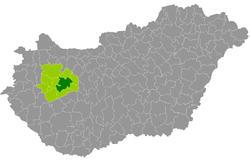 Veszprém District within Hungary and Veszprém County. | |
| Country | |
| County | Veszprém |
| District seat | Veszprém (town) |
| Area | |
| • Total | 629.61 km2 (243.09 sq mi) |
| Area rank | 2nd in Veszprém |
| Population (2011 census) | |
| • Total | 83,288 |
| • Rank | 1st in Veszprém |
| • Density | 132/km2 (340/sq mi) |
Geography
Veszprém District borders with Zirc District to the north, Várpalota District and Balatonalmádi District to the east, Balatonfüred District to the south, Tapolca District, Ajka District and Pápa District to the west. The number of the inhabited places in Veszprém District is 19.
Municipalities
The district has 1 urban county, 1 town and 17 villages. (ordered by population, as of 1 January 2013)[1]
- Barnag (132)
- Bánd (665)
- Eplény (516)
- Hajmáskér (2,865)
- Hárskút (689)
- Herend (3,377)
- Hidegkút (417)
- Márkó (1,216)
- Mencshely (239)
- Nagyvázsony (1,760)
- Nemesvámos (2,627)
- Pula (195)
- Sóly (474)
- Szentgál (2,762)
- Szentkirályszabadja (1,920)
- Tótvázsony (1,297)
- Veszprém (60,876) – district and county seat
- Veszprémfajsz (243)
- Vöröstó (83)
The bolded municipalities are cities.
gollark: Is coast EMPTY?
gollark: I can offer these mageiaæ, but I should *probably* keep them for my IOU.
gollark: _is out of random nonsense_
gollark: Aeons? Time to offer RANDOM NONSENSE!
gollark: I could probably IOU for some, but there's sure to be *one* odd person on the hub with four right now.
See also
- List of cities and towns in Hungary
References
This article is issued from Wikipedia. The text is licensed under Creative Commons - Attribution - Sharealike. Additional terms may apply for the media files.