Ajka District
Ajka (Hungarian: Ajkai járás) is a district in central-western part of Veszprém County. Ajka is also the name of the town where the district seat is found. The district is located in the Central Transdanubia Statistical Region.
Ajka District Ajkai járás | |
|---|---|
 Coat of arms | |
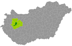 Ajka District within Hungary and Veszprém County. | |
| Country | |
| County | Veszprém |
| District seat | Ajka |
| Area | |
| • Total | 320.71 km2 (123.83 sq mi) |
| Area rank | 7th in Veszprém |
| Population (2011 census) | |
| • Total | 39,160 |
| • Rank | 3rd in Veszprém |
| • Density | 122/km2 (320/sq mi) |
Geography
Ajka District borders with Pápa District to the north, Veszprém District to the east, Tapolca District to the south, Sümeg District and Devecser District to the west. The number of the inhabited places in Ajka District is 11.
Municipalities
The district has 1 town and 10 villages.[1]
The bolded municipality is city.
gollark: Ibsfall that
gollark: https://pastebin.com/ZfhJz6n4
gollark: Hold on.
gollark: Why don't you?
gollark: My prediction was based on predicted travel time of laser from current distance multiplied by current velocity.
See also
- List of cities and towns in Hungary
References
- "A KSH 2013. évi helységnévkönyve". ksh.hu. Retrieved 2017-10-27.
This article is issued from Wikipedia. The text is licensed under Creative Commons - Attribution - Sharealike. Additional terms may apply for the media files.