Vernár
Vernár is a village and large municipality in Poprad District in the Prešov Region of northern Slovakia.[1] It lies between Low Tatras and Slovenský raj mountain ranges.
Vernár | |
|---|---|
Municipality | |
 | |
 Coat of arms | |
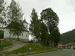
 Vernár Location of Vernár in Slovakia | |
| Coordinates: 48°55′04″N 20°16′13″E | |
| Country | Slovakia |
| Region | Prešov |
| District | Poprad |
| Area | |
| • Total | 52.880281 km2 (20.417191 sq mi) |
| Elevation | 765 m (2,510 ft) |
| Population (31 December 2010) | |
| • Total | 599 |
| • Density | 11/km2 (29/sq mi) |
| Postal code | 059 17 |
| Area code(s) | +421-52 |
| Car plate | PP |
| Website | www.vernar.sk |
History
In historical records the village was first mentioned in 1295.
Geography
The municipality lies at an altitude of 765 metres and covers an area of 52.901 km². It has a population of about 600 people.
Economy and infrastructure
In a village is football club, chess club and a ski-lift area. Cultural sightseeings are classical church from the 19th century and well preserved folk architecture.
gollark: Yes, but you need to do that too.
gollark: `apt update && apt upgrade` actually.
gollark: On (Arch) Linux I can just run `sudo pacman -Syu` and it conveniently updates in the background!
gollark: I mean, I use Google Play for apps, but much of my stuff is from F-droid anyway.
gollark: Oh, I don't use Google services, but *lots of people* do.
References
- "Statistical Office of the Slovak Republic" (PDF). Výsledky SODB 2011. Štatistický úrad SR. Archived from the original (PDF) on October 12, 2013. Retrieved 9 August 2012.
External links
- http://vernar.e-obce.sk
- http://www.vernar.sk/ (www.vernar.sk)
Municipalities of Poprad District | ||
|---|---|---|
This article is issued from Wikipedia. The text is licensed under Creative Commons - Attribution - Sharealike. Additional terms may apply for the media files.