Vermont Route 109
Vermont Route 109 (VT 109) is a 14.800-mile-long (23.818 km) state highway in the U.S. state of Vermont. It begins at VT 108 in the town of Cambridge and ends at VT 118 in Belvidere.
| ||||
|---|---|---|---|---|
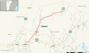 Map of Lamoille County in northern Vermont with VT 109 highlighted in red | ||||
| Route information | ||||
| Maintained by VTrans | ||||
| Length | 14.800 mi[1] (23.818 km) | |||
| Major junctions | ||||
| South end | ||||
| North end | ||||
| Location | ||||
| Counties | Lamoille | |||
| Highway system | ||||
State highways in Vermont
| ||||

Route description
The routes starts at VT 108 going east for a short period, and then turning to the northeast. While going in this direction, the route goes through the town of Waterville. The road then turns to the east and finally ends at a roundabout intersection with VT 118.
Major intersections
The entire route is in Lamoille County. [1]
| Location[1] | mi[1] | km | Destinations | Notes | |
|---|---|---|---|---|---|
| Cambridge | 0.000 | 0.000 | Southern terminus | ||
| Belvidere | 14.800 | 23.818 | Northern terminus | ||
| 1.000 mi = 1.609 km; 1.000 km = 0.621 mi | |||||
gollark: Technically, GNSS is more accurate.
gollark: Does it work using satellites of some sort or an older-style land-based system?
gollark: Well, logically, my phone should have support for this in magic-having areas. Excellent.
gollark: Did someone make a GPS equivalent?
gollark: As planned.
References
- Traffic Research Unit (May 2013). "2012 (Route Log) AADTs for State Highways" (PDF). Policy, Planning and Intermodal Development Division, Vermont Agency of Transportation. Retrieved March 27, 2015.
External links
This article is issued from Wikipedia. The text is licensed under Creative Commons - Attribution - Sharealike. Additional terms may apply for the media files.