Vermont Route 108
Vermont Route 108 (VT 108) is a north–south state highway in northern Vermont, United States. Its southern terminus is at VT 100 in Stowe, and its northern terminus is at the Canada–US border in Franklin, where it continues into Quebec past the West Berkshire–Frelighsburg Border Crossing as Route 237. VT 108 is 45.450 miles (73.145 km) long.
| ||||
|---|---|---|---|---|
| 10th Mountain Division Memorial Highway[1] | ||||
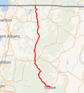
VT 108 highlighted in red | ||||
| Route information | ||||
| Maintained by VTrans | ||||
| Length | 45.450 mi[2] (73.145 km) | |||
| Major junctions | ||||
| South end | ||||
| ||||
| North end | ||||
| Location | ||||
| Counties | Lamoille, Franklin | |||
| Highway system | ||||
State highways in Vermont
| ||||

Route description
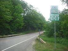
VT 108 passes through the area of the Mount Mansfield State Forest. It starts in Stowe and goes through Smugglers' Notch to Jeffersonville. The road cuts through Mount Mansfield. The road is very steep and turning, making it impossible to plow in the winter,[3] so the road is closed usually from mid-October until May. Tractor-trailers are barred from this section, though several trucks continue to get stuck every year[4]. Large straight trucks, buses and RVs are strongly encouraged to find other routes year-round. However, skiers come from alternate routes to cross-country, downhill ski, and snow mobile in the Smuggler's Notch Resort. Along the road, there are small parking areas where rock climbing and hiking are popular.
Major intersections
| County | Location[2] | mi[2] | km | Destinations | Notes |
|---|---|---|---|---|---|
| Lamoille | Stowe | 0.000 | 0.000 | Southern terminus | |
| Cambridge | 17.383 | 27.975 | Village of Jeffersonville | ||
| 17.696 | 28.479 | Village of Jeffersonville; roundabout | |||
| 18.142 | 29.197 | Southern terminus of VT 109 | |||
| Franklin | Bakersfield | 27.785 | 44.716 | Eastern terminus of VT 36 | |
| Enosburg | 37.040 | 59.610 | Village of Enosburg Falls; southern end of concurrency with VT 105 | ||
| 37.544 | 60.421 | Northern end of concurrency with VT 105 | |||
| Berkshire | 43.347[5] | 69.760 | Northern terminus of VT 118 | ||
| 44.111 | 70.990 | Northern terminus of VT 120 | |||
| 45.450 | 73.145 | Continuation into Quebec | |||
1.000 mi = 1.609 km; 1.000 km = 0.621 mi
| |||||
References
- State of Vermont Board of Libraries (April 28, 2008). "Vermont Named State Highways and Bridges" (PDF). Department of Libraries, State of Vermont. Retrieved April 1, 2015.
- Traffic Research Unit (May 2013). "2012 (Route Log) AADTs for State Highways" (PDF). Policy, Planning and Intermodal Development Division, Vermont Agency of Transportation. Retrieved March 27, 2015.
- "Travel Guide of America". Retrieved 2009-01-02.
- Murray, Elizabeth. "Attention tractor trailer drivers: Avoid Smugglers Notch road or face a hefty fine". Burlington Free Press. Retrieved 4 May 2020.
- Division of Policy, Planning and Intermodal Development (October 2, 2014). "Vermont General Highway Map, Town of Berkshire, Franklin County" (PDF). Vermont Agency of Transportation. Retrieved April 1, 2015.
External links
| Wikimedia Commons has media related to Vermont Route 108. |