Velence Hills
Velence Hills (Hungarian: Velencei-hegység) is a low mountain range in north-western Hungary, in the Central Transdanubian region. It lies to the north of Lake Velence, some 15 km to the east of city of Székesfehérvár. The Velence Hills are part of the Transdanubian Mountains. Village of Nadap lies in the central part of the hills and is the point of departure of excursions to the countryside.[1] The highest point, Meleg-hegy ("Hot hill") (352 m) lies above the village.[2]
| Velence Hills | |
|---|---|
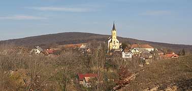 Nadap on the Velence Hills | |
| Highest point | |
| Peak | Meleg-hegy, 47.259038°N 18.596496°E |
| Elevation | 352 m (1,155 ft) |
| Geography | |
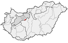 | |
| Country | Hungary |
| County | Fejér County |
| Geology | |
| Orogeny | Transdanubian Mountains |
Gallery

gollark: Not real.
gollark: Rust is annoyingly inflexible and slow to compile and dependencyuous. Nim has a bad ecosystem and is kind of unpolished.
gollark: There are no good programming languages, sadly.
gollark: I would either use Rust or Nim. But both are annoying in some ways.
gollark: The project is currently shelved due to the caching interacting poorly with dynamic sites and the lack of programming languages sufficient to contain the power it wields.
References
- "Nadap". 1Hungary. Retrieved 11 August 2017.
- "A település bemutatása". Official website of Nadap (in Hungarian). Retrieved 11 August 2017.
External links

| West-Hungarian Borderland |
| 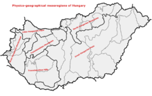 Physico-geographical mesoregions of Hungary |
|---|---|---|
| Little Hungarian Plain |
| |
| Transdanubia |
| |
| Transdanubian Mountains |
| |
| Transdanubian Hills |
| |
| North Hungarian Mountains | ||
| Great Hungarian Plain | ||
This article is issued from Wikipedia. The text is licensed under Creative Commons - Attribution - Sharealike. Additional terms may apply for the media files.